
Spenden
Rüsten Sie sich für Ihr nächstes Abenteuer:
Als Amazon-Partner erhält diese Website eine Provision für qualifizierte Käufe, ohne zusätzliche Kosten für Sie.
Topografische Karte Mount Washburn
Klicken Sie auf die Karte, um die Höhe anzuzeigen.
Spenden
Rüsten Sie sich für Ihr nächstes Abenteuer:
Als Amazon-Partner erhält diese Website eine Provision für qualifizierte Käufe, ohne zusätzliche Kosten für Sie.
Mount Washburn
Mount Washburn, elevation 10,219 feet (3,115 m), is a prominent mountain peak in the Washburn Range in Yellowstone National Park, Wyoming. The peak was named in 1870 to honor Henry D. Washburn, leader of the Washburn–Langford–Doane Expedition. The Washburn Range is one of two mountains ranges completely within the boundaries of Yellowstone.
Spenden
Rüsten Sie sich für Ihr nächstes Abenteuer:
Als Amazon-Partner erhält diese Website eine Provision für qualifizierte Käufe, ohne zusätzliche Kosten für Sie.
Über diese Karte
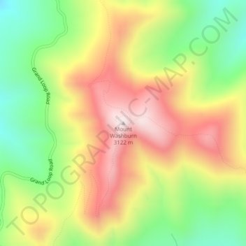
Name: Topografische Karte Mount Washburn, Höhe, Relief.
Ort: Mount Washburn, Park County, Wyoming, United States (44.79751 -110.43384 44.79761 -110.43374)
Durchschnittliche Höhe: 2.798 m
Minimale Höhe: 2.503 m
Maximale Höhe: 3.109 m
Spenden
Rüsten Sie sich für Ihr nächstes Abenteuer:
Als Amazon-Partner erhält diese Website eine Provision für qualifizierte Käufe, ohne zusätzliche Kosten für Sie.
Andere topografische Karten
Klicken Sie auf eine Karte, um ihre Topografie, ihre Höhe und ihr Relief anzuzeigen.
Cody
United States > Wyoming > Park County
Cody's elevation is approximately 5016 ft (1,500 m) above sea level. The main part of the city is split across three levels, separated by about 60 feet (18 m).
Durchschnittliche Höhe: 1.557 m
Cody
United States > Wyoming > Park County
Cody's elevation is approximately 5016 ft (1,500 m) above sea level. The main part of the city is split across three levels, separated by about 60 feet (18 m).
Durchschnittliche Höhe: 1.557 m
Spenden
Rüsten Sie sich für Ihr nächstes Abenteuer:
Als Amazon-Partner erhält diese Website eine Provision für qualifizierte Käufe, ohne zusätzliche Kosten für Sie.
Cody
United States > Wyoming > Park County
Cody's elevation is approximately 4,997 feet (1,523 m) above sea level. The main part of the city is split across three levels, separated by about 60 feet (18 m).
Durchschnittliche Höhe: 1.557 m