
Topografische Karte Asnières-sur-Seine
Interaktive Karte
Klicken Sie auf die Karte, um die Höhe anzuzeigen.
Über diese Karte
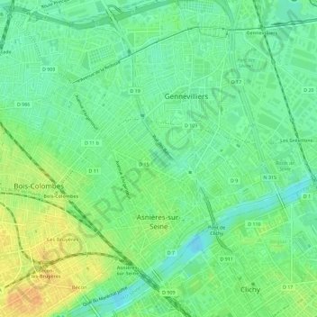
Name: Topografische Karte Asnières-sur-Seine, Höhe, Relief.
Durchschnittliche Höhe: 35 m
Minimale Höhe: 21 m
Maximale Höhe: 53 m
La superficie de la commune est de 482 hectares ; l'altitude varie de 22 à 43 mètres.
Andere topografische Karten
Klicken Sie auf eine Karte, um ihre Topografie, ihre Höhe und ihr Relief anzuzeigen.
La Garenne-Colombes
France > Île-de-France > Hauts-de-Seine
La Garenne-Colombes, Nanterre, Hauts-de-Seine, Île-de-France, France métropolitaine, 92250, France
Durchschnittliche Höhe: 45 m
Bourg-la-Reine
France > Île-de-France > Hauts-de-Seine
Bourg-la-Reine, Antony, Hauts-de-Seine, Île-de-France, France métropolitaine, 92340, France
Durchschnittliche Höhe: 70 m
Colombes
France > Île-de-France > Hauts-de-Seine
Colombes, Nanterre, Hauts-de-Seine, Île-de-France, France métropolitaine, 92700, France
Durchschnittliche Höhe: 37 m
Puteaux
France > Île-de-France > Hauts-de-Seine
Puteaux, Nanterre, Hauts-de-Seine, Île-de-France, France métropolitaine, 92800, France
Durchschnittliche Höhe: 52 m
Châtenay-Malabry
France > Île-de-France > Hauts-de-Seine
Châtenay-Malabry, Antony, Hauts-de-Seine, Île-de-France, France métropolitaine, 92290, France
Durchschnittliche Höhe: 111 m
Quartier Mont-Valérien
France > Île-de-France > Hauts-de-Seine > Suresnes
Quartier Mont-Valérien, Suresnes, Nanterre, Hauts-de-Seine, Île-de-France, France métropolitaine, 92150, France
Durchschnittliche Höhe: 76 m
Le Plessis-Robinson
France > Île-de-France > Hauts-de-Seine > Le Plessis-Robinson
Le Plessis-Robinson, Antony, Hauts-de-Seine, Île-de-France, France métropolitaine, 92350, France
Durchschnittliche Höhe: 146 m
Clichy
France > Île-de-France > Hauts-de-Seine
Clichy, Nanterre, Hauts-de-Seine, Île-de-France, France métropolitaine, 92110, France
Durchschnittliche Höhe: 36 m
Saint-Cloud
France > Île-de-France > Hauts-de-Seine
Saint-Cloud, Nanterre, Hauts-de-Seine, Île-de-France, France métropolitaine, 92210, France
Durchschnittliche Höhe: 71 m
Nanterre
France > Île-de-France > Hauts-de-Seine
Nanterre, Hauts-de-Seine, Île-de-France, France métropolitaine, 92000, France
Durchschnittliche Höhe: 45 m
Malakoff
France > Île-de-France > Hauts-de-Seine
Malakoff, Antony, Hauts-de-Seine, Île-de-France, France métropolitaine, 92240, France
Durchschnittliche Höhe: 74 m
Meudon
France > Île-de-France > Hauts-de-Seine
Meudon, Boulogne-Billancourt, Hauts-de-Seine, Île-de-France, France métropolitaine, France
Durchschnittliche Höhe: 132 m
Centre-Ville
France > Île-de-France > Hauts-de-Seine > Asnières-sur-Seine
Centre-Ville, Asnières-sur-Seine, Nanterre, Hauts-de-Seine, Île-de-France, France métropolitaine, 92600, France
Durchschnittliche Höhe: 35 m