
Topografische Karte Malakoff
Interaktive Karte
Klicken Sie auf die Karte, um die Höhe anzuzeigen.
Über diese Karte
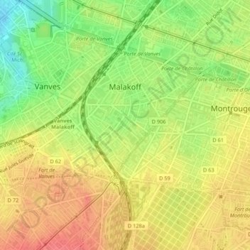
Name: Topografische Karte Malakoff, Höhe, Relief.
Durchschnittliche Höhe: 74 m
Minimale Höhe: 34 m
Maximale Höhe: 103 m
La superficie de la commune est de 207 hectares. Le sol est pratiquement plat. la pente moyenne est de 0,015 par mètre et la pente maximum de 0,03 par mètre. L'altitude varie entre 64 mètres (limite de Paris) et 95 mètres (partie ouest du fort de Vanves).
Andere topografische Karten
Klicken Sie auf eine Karte, um ihre Topografie, ihre Höhe und ihr Relief anzuzeigen.
La Garenne-Colombes
France > Île-de-France > Hauts-de-Seine
La Garenne-Colombes, Nanterre, Hauts-de-Seine, Île-de-France, France métropolitaine, 92250, France
Durchschnittliche Höhe: 45 m
Bourg-la-Reine
France > Île-de-France > Hauts-de-Seine
Bourg-la-Reine, Antony, Hauts-de-Seine, Île-de-France, France métropolitaine, 92340, France
Durchschnittliche Höhe: 70 m
Colombes
France > Île-de-France > Hauts-de-Seine
Colombes, Nanterre, Hauts-de-Seine, Île-de-France, France métropolitaine, 92700, France
Durchschnittliche Höhe: 37 m
Puteaux
France > Île-de-France > Hauts-de-Seine
Puteaux, Nanterre, Hauts-de-Seine, Île-de-France, France métropolitaine, 92800, France
Durchschnittliche Höhe: 52 m
Châtenay-Malabry
France > Île-de-France > Hauts-de-Seine
Châtenay-Malabry, Antony, Hauts-de-Seine, Île-de-France, France métropolitaine, 92290, France
Durchschnittliche Höhe: 111 m
Quartier Mont-Valérien
France > Île-de-France > Hauts-de-Seine > Suresnes
Quartier Mont-Valérien, Suresnes, Nanterre, Hauts-de-Seine, Île-de-France, France métropolitaine, 92150, France
Durchschnittliche Höhe: 76 m
Asnières-sur-Seine
France > Île-de-France > Hauts-de-Seine
Asnières-sur-Seine, Nanterre, Hauts-de-Seine, Île-de-France, France métropolitaine, 92600, France
Durchschnittliche Höhe: 35 m
Le Plessis-Robinson
France > Île-de-France > Hauts-de-Seine > Le Plessis-Robinson
Le Plessis-Robinson, Antony, Hauts-de-Seine, Île-de-France, France métropolitaine, 92350, France
Durchschnittliche Höhe: 146 m
Clichy
France > Île-de-France > Hauts-de-Seine
Clichy, Nanterre, Hauts-de-Seine, Île-de-France, France métropolitaine, 92110, France
Durchschnittliche Höhe: 36 m
Saint-Cloud
France > Île-de-France > Hauts-de-Seine
Saint-Cloud, Nanterre, Hauts-de-Seine, Île-de-France, France métropolitaine, 92210, France
Durchschnittliche Höhe: 71 m
Nanterre
France > Île-de-France > Hauts-de-Seine
Nanterre, Hauts-de-Seine, Île-de-France, France métropolitaine, 92000, France
Durchschnittliche Höhe: 45 m
Meudon
France > Île-de-France > Hauts-de-Seine
Meudon, Boulogne-Billancourt, Hauts-de-Seine, Île-de-France, France métropolitaine, France
Durchschnittliche Höhe: 132 m
Centre-Ville
France > Île-de-France > Hauts-de-Seine > Asnières-sur-Seine
Centre-Ville, Asnières-sur-Seine, Nanterre, Hauts-de-Seine, Île-de-France, France métropolitaine, 92600, France
Durchschnittliche Höhe: 35 m