
Topografische Karte King Peak
Interaktive Karte
Klicken Sie auf die Karte, um die Höhe anzuzeigen.
Über diese Karte
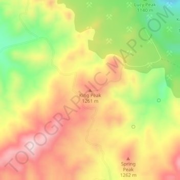
Name: Topografische Karte King Peak, Höhe, Relief.
Ort: King Peak, Yavapai County, Arizona, VS (34.56525 -113.23053 34.56535 -113.23043)
Durchschnittliche Höhe: 1.179 m
Minimale Höhe: 995 m
Maximale Höhe: 1.332 m
Andere topografische Karten
Klicken Sie auf eine Karte, um ihre Topografie, ihre Höhe und ihr Relief anzuzeigen.
Saguaro National Park
Saguaro National Park, Quilter Trail, Pima County, Arizona, VS
Durchschnittliche Höhe: 1.174 m
Petrified Forest National Park
Petrified Forest National Park, Apache County, Arizona, 86028, VS
Durchschnittliche Höhe: 1.722 m
Humphreys Peak
Humphreys Peak, Coconino County, Arizona, VS
Durchschnittliche Höhe: 3.413 m
Cuates Butte
Cuates Butte, Santa Cruz County, Arizona, 85628, VS
Durchschnittliche Höhe: 1.132 m
Canyon de Chelly National Monument
Canyon de Chelly National Monument, Apache County, Arizona, VS
Durchschnittliche Höhe: 1.770 m