Geolokalisieren

Topografische Karte Saguaro National Park

Interaktive Karte

Klicken Sie auf die Karte, um die Höhe anzuzeigen.

Über diese Karte

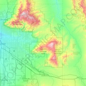
Name: Topografische Karte Saguaro National Park, Höhe, Relief.

Ort: Saguaro National Park, Quilter Trail, Pima County, Arizona, VS (32.10403 -111.24383 32.35206 -110.49850)

Durchschnittliche Höhe: 1.174 m

Minimale Höhe: 699 m

Maximale Höhe: 2.784 m

Andere topografische Karten

Klicken Sie auf eine Karte, um ihre Topografie, ihre Höhe und ihr Relief anzuzeigen.

Bagdad

VS > Arizona > Bagdad

Bagdad, Manzanita Court, Bagdad, Yavapai County, Arizona, 86321, VS

Durchschnittliche Höhe: 1.181 m

Yuma

VS > Arizona > Yuma

Yuma, Yuma County, Arizona, 85364, VS

Durchschnittliche Höhe: 69 m

Humphreys Peak

VS > Arizona

Humphreys Peak, Coconino County, Arizona, VS

Durchschnittliche Höhe: 3.413 m

Flagstaff

VS > Arizona > Flagstaff

Flagstaff, Coconino County, Arizona, VS

Durchschnittliche Höhe: 2.176 m

Cuates Butte

VS > Arizona

Cuates Butte, Santa Cruz County, Arizona, 85628, VS

Durchschnittliche Höhe: 1.132 m

King Peak

VS > Arizona

King Peak, Yavapai County, Arizona, VS

Durchschnittliche Höhe: 1.179 m

Canyon de Chelly National Monument

VS > Arizona

Canyon de Chelly National Monument, Apache County, Arizona, VS

Durchschnittliche Höhe: 1.770 m

Mesa

VS > Arizona > Mesa

Mesa, Maricopa County, Arizona, VS

Durchschnittliche Höhe: 385 m

Eloy

VS > Arizona > Eloy

Eloy, Pinal County, Arizona, 85131, VS

Durchschnittliche Höhe: 478 m

Petrified Forest National Park

VS > Arizona

Petrified Forest National Park, Apache County, Arizona, 86028, VS

Durchschnittliche Höhe: 1.722 m