
Topografische Karte Snow Hill
Interaktive Karte
Klicken Sie auf die Karte, um die Höhe anzuzeigen.
Über diese Karte
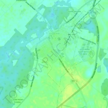
Name: Topografische Karte Snow Hill, Höhe, Relief.
Ort: Snow Hill, Worcester County, Maryland, United States (38.15085 -75.40553 38.18877 -75.37540)
Durchschnittliche Höhe: 7 m
Minimale Höhe: -1 m
Maximale Höhe: 15 m
Snow Hill was founded in 1686 in Somerset County by English settlers, who may have named it after a street and neighborhood of the City of London called "Snow Hill", despite the location's elevation of just 16 feet (4.9 m) above sea level and the infrequency of snowfall. The town received its first charter on October 26, 1686, and was made a port of entry in 1694.
Andere topografische Karten
Klicken Sie auf eine Karte, um ihre Topografie, ihre Höhe und ihr Relief anzuzeigen.
West Ocean City
United States > Maryland > Worcester County > West Ocean City
West Ocean City, Worcester County, Maryland, United States
Durchschnittliche Höhe: 2 m
Ocean City
United States > Maryland > Worcester County
Ocean City, Worcester County, Maryland, United States
Durchschnittliche Höhe: 1 m
Stockton
United States > Maryland > Worcester County > Stockton
Stockton, Worcester County, Maryland, United States
Durchschnittliche Höhe: 8 m
Ocean Pines
United States > Maryland > Worcester County
Ocean Pines, Worcester County, Maryland, United States
Durchschnittliche Höhe: 3 m
Assateague Island National Seashore
United States > Maryland > Worcester County > West Ocean City
Assateague Island National Seashore, West Ocean City, Worcester County, Maryland, United States
Durchschnittliche Höhe: 2 m
Newark
United States > Maryland > Worcester County > Newark
Newark, Worcester County, Maryland, United States
Durchschnittliche Höhe: 10 m
Worcester County
United States > Maryland > Worcester County
Worcester County, Maryland, United States
Durchschnittliche Höhe: 6 m