
Topografische Karte Ocean Pines
Interaktive Karte
Klicken Sie auf die Karte, um die Höhe anzuzeigen.
Über diese Karte
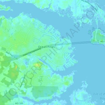
Name: Topografische Karte Ocean Pines, Höhe, Relief.
Ort: Ocean Pines, Worcester County, Maryland, United States (38.35395 -75.18603 38.40950 -75.10656)
Durchschnittliche Höhe: 3 m
Minimale Höhe: -4 m
Maximale Höhe: 17 m
Andere topografische Karten
Klicken Sie auf eine Karte, um ihre Topografie, ihre Höhe und ihr Relief anzuzeigen.
West Ocean City
United States > Maryland > Worcester County > West Ocean City
West Ocean City, Worcester County, Maryland, United States
Durchschnittliche Höhe: 2 m
Ocean City
United States > Maryland > Worcester County
Ocean City, Worcester County, Maryland, United States
Durchschnittliche Höhe: 1 m
Stockton
United States > Maryland > Worcester County > Stockton
Stockton, Worcester County, Maryland, United States
Durchschnittliche Höhe: 8 m
Snow Hill
United States > Maryland > Worcester County
Snow Hill, Worcester County, Maryland, United States
Durchschnittliche Höhe: 7 m
Assateague Island National Seashore
United States > Maryland > Worcester County > West Ocean City
Assateague Island National Seashore, West Ocean City, Worcester County, Maryland, United States
Durchschnittliche Höhe: 2 m
Newark
United States > Maryland > Worcester County > Newark
Newark, Worcester County, Maryland, United States
Durchschnittliche Höhe: 10 m
Worcester County
United States > Maryland > Worcester County
Worcester County, Maryland, United States
Durchschnittliche Höhe: 6 m