
Topografische Karte Meredith
Interaktive Karte
Klicken Sie auf die Karte, um die Höhe anzuzeigen.
Über diese Karte
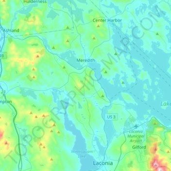
Name: Topografische Karte Meredith, Höhe, Relief.
Durchschnittliche Höhe: 215 m
Minimale Höhe: 142 m
Maximale Höhe: 718 m
According to the United States Census Bureau, the town has a total area of 54.6 square miles (141.3 km2), of which 40.1 square miles (103.8 km2) are land and 14.5 square miles (37.5 km2), or 26.37%, are water. The highest point in Meredith is the summit of Leavitt Mountain, elevation 1,414 feet (431 m) above sea level, in the southwestern part of town.
Andere topografische Karten
Klicken Sie auf eine Karte, um ihre Topografie, ihre Höhe und ihr Relief anzuzeigen.
Lake Winnipesaukee
United States > New Hampshire > Belknap County > Alton
Lake Winnipesaukee, Alton, Belknap County, New Hampshire, 03226, United States
Durchschnittliche Höhe: 223 m
The Plains
United States > New Hampshire > Belknap County > Tilton
The Plains, Tilton, Belknap County, New Hampshire, 03252, United States
Durchschnittliche Höhe: 167 m
Mallard Cove
United States > New Hampshire > Belknap County > Laconia
Mallard Cove, Laconia, Belknap County, New Hampshire, 03246, United States
Durchschnittliche Höhe: 173 m
Sanbornton
United States > New Hampshire > Belknap County
Sanbornton, Belknap County, New Hampshire, 03269, United States
Durchschnittliche Höhe: 228 m
Gilford
United States > New Hampshire > Belknap County
Gilford, Belknap County, New Hampshire, 03249, United States
Durchschnittliche Höhe: 231 m
Tilton
United States > New Hampshire > Belknap County
Tilton, Belknap County, New Hampshire, United States
Durchschnittliche Höhe: 196 m
Barnstead
United States > New Hampshire > Belknap County
Barnstead, Belknap County, New Hampshire, United States
Durchschnittliche Höhe: 221 m