
Topografische Karte Tilton
Interaktive Karte
Klicken Sie auf die Karte, um die Höhe anzuzeigen.
Über diese Karte
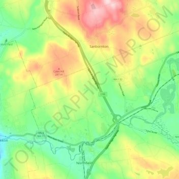
Name: Topografische Karte Tilton, Höhe, Relief.
Ort: Tilton, Belknap County, New Hampshire, United States (43.43489 -71.62881 43.50224 -71.51075)
Durchschnittliche Höhe: 196 m
Minimale Höhe: 85 m
Maximale Höhe: 356 m
Andere topografische Karten
Klicken Sie auf eine Karte, um ihre Topografie, ihre Höhe und ihr Relief anzuzeigen.
Lake Winnipesaukee
United States > New Hampshire > Belknap County > Alton
Lake Winnipesaukee, Alton, Belknap County, New Hampshire, 03226, United States
Durchschnittliche Höhe: 223 m
The Plains
United States > New Hampshire > Belknap County > Tilton
The Plains, Tilton, Belknap County, New Hampshire, 03252, United States
Durchschnittliche Höhe: 167 m
Mallard Cove
United States > New Hampshire > Belknap County > Laconia
Mallard Cove, Laconia, Belknap County, New Hampshire, 03246, United States
Durchschnittliche Höhe: 173 m
Sanbornton
United States > New Hampshire > Belknap County
Sanbornton, Belknap County, New Hampshire, 03269, United States
Durchschnittliche Höhe: 228 m
Gilford
United States > New Hampshire > Belknap County
Gilford, Belknap County, New Hampshire, 03249, United States
Durchschnittliche Höhe: 231 m
Meredith
United States > New Hampshire > Belknap County
Meredith, Belknap County, New Hampshire, 03253, United States
Durchschnittliche Höhe: 215 m
Barnstead
United States > New Hampshire > Belknap County
Barnstead, Belknap County, New Hampshire, United States
Durchschnittliche Höhe: 221 m