
Topografische Karte Bear Mountain State Park
Interaktive Karte
Klicken Sie auf die Karte, um die Höhe anzuzeigen.
Über diese Karte
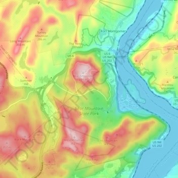
Name: Topografische Karte Bear Mountain State Park, Höhe, Relief.
Durchschnittliche Höhe: 166 m
Minimale Höhe: 0 m
Maximale Höhe: 394 m
There are over 50 official trails covering 235 miles (378 km), featuring a wide range of difficulties and elevation changes.
Andere topografische Karten
Klicken Sie auf eine Karte, um ihre Topografie, ihre Höhe und ihr Relief anzuzeigen.
Tomkins Cove
United States > New York > Rockland County > Town of Stony Point
Tomkins Cove, Town of Stony Point, Rockland County, New York, 10986, United States
Durchschnittliche Höhe: 68 m
Buckberg
United States > New York > Rockland County > Town of Stony Point
Buckberg, Town of Stony Point, Rockland County, New York, 10986, United States
Durchschnittliche Höhe: 108 m
Lake Welch
United States > New York > Rockland County > Town of Stony Point
Lake Welch, Town of Stony Point, Rockland County, New York, United States
Durchschnittliche Höhe: 324 m