
Topografische Karte Tomkins Cove
Interaktive Karte
Klicken Sie auf die Karte, um die Höhe anzuzeigen.
Über diese Karte
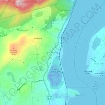
Name: Topografische Karte Tomkins Cove, Höhe, Relief.
Durchschnittliche Höhe: 68 m
Minimale Höhe: -43 m
Maximale Höhe: 322 m
Andere topografische Karten
Klicken Sie auf eine Karte, um ihre Topografie, ihre Höhe und ihr Relief anzuzeigen.
Buckberg
United States > New York > Rockland County > Town of Stony Point
Buckberg, Town of Stony Point, Rockland County, New York, 10986, United States
Durchschnittliche Höhe: 108 m
Lake Welch
United States > New York > Rockland County > Town of Stony Point
Lake Welch, Town of Stony Point, Rockland County, New York, United States
Durchschnittliche Höhe: 324 m
Bear Mountain State Park
United States > New York > Rockland County > Town of Stony Point
Bear Mountain State Park, Town of Stony Point, Town of Highlands, Rockland County, New York, United States
Durchschnittliche Höhe: 166 m