
Topografische Karte La Brosse
Interaktive Karte
Klicken Sie auf die Karte, um die Höhe anzuzeigen.
Über diese Karte
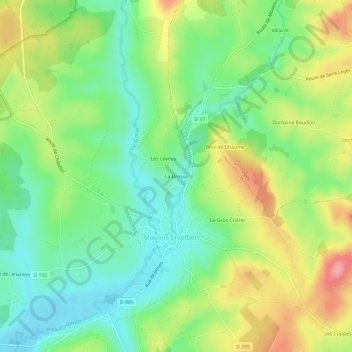
Name: Topografische Karte La Brosse, Höhe, Relief.
Durchschnittliche Höhe: 263 m
Minimale Höhe: 215 m
Maximale Höhe: 339 m
Andere topografische Karten
Klicken Sie auf eine Karte, um ihre Topografie, ihre Höhe und ihr Relief anzuzeigen.
Crot Manigot
France > Bourgogne-Franche-Comté > Nièvre > Moulins-Engilbert > Margoulet
Crot Manigot, Margoulet, Moulins-Engilbert, Château-Chinon (Ville), Nièvre, Bourgogne-Franche-Comté, France métropolitaine, 58290, France
Durchschnittliche Höhe: 338 m
Les Coppes
France > Bourgogne-Franche-Comté > Nièvre > Moulins-Engilbert
Les Coppes, Moulins-Engilbert, Château-Chinon (Ville), Nièvre, Bourgogne-Franche-Comté, France métropolitaine, 58290, France
Durchschnittliche Höhe: 300 m
Les Champs Brideaux
France > Bourgogne-Franche-Comté > Nièvre > Moulins-Engilbert
Les Champs Brideaux, Moulins-Engilbert, Château-Chinon (Ville), Nièvre, Bourgogne-Franche-Comté, France métropolitaine, 58290, France
Durchschnittliche Höhe: 294 m
Moulin de Commagny
France > Bourgogne-Franche-Comté > Nièvre > Moulins-Engilbert > Compagny le Prieuré
Moulin de Commagny, Compagny le Prieuré, Moulins-Engilbert, Château-Chinon (Ville), Nièvre, Bourgogne-Franche-Comté, France métropolitaine, 58290, France
Durchschnittliche Höhe: 245 m