
Topografische Karte Trident Volcano
Interaktive Karte
Klicken Sie auf die Karte, um die Höhe anzuzeigen.
Über diese Karte
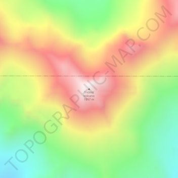
Name: Topografische Karte Trident Volcano, Höhe, Relief.
Ort: Trident Volcano, Kodiak Island, Alaska, United States (58.23425 -155.10265 58.23435 -155.10255)
Durchschnittliche Höhe: 1.338 m
Minimale Höhe: 857 m
Maximale Höhe: 1.845 m
Trident Volcano is an eroded volcanic complex on the Alaska Peninsula in Katmai National Park, Alaska. Up to 23 domes comprise the complex stratovolcano, with the greatest elevation of 6,115 feet (1,864 m). The most recent major activity produced a 3,599-foot (1,097 m) dome in an amphitheater on the southwest flank of the southwest peak. Volcano Novarupta formed on its slopes in the largest volcanic eruption of the 20th century.
Andere topografische Karten
Klicken Sie auf eine Karte, um ihre Topografie, ihre Höhe und ihr Relief anzuzeigen.
Raspberry Island
United States > Alaska > Kodiak Island
Raspberry Island, Kodiak Island, Alaska, United States
Durchschnittliche Höhe: 71 m
Woody Island
United States > Alaska > Kodiak Island
Woody Island, Kodiak Island, Alaska, United States
Durchschnittliche Höhe: 9 m
Mount Katmai
United States > Alaska > Kodiak Island
Mount Katmai, Kodiak Island, Alaska, United States
Durchschnittliche Höhe: 1.507 m
Kodiak
United States > Alaska > Kodiak Island
Kodiak, Kodiak Island, Alaska, United States
Durchschnittliche Höhe: 62 m