
Topografische Karte Woody Island
Interaktive Karte
Klicken Sie auf die Karte, um die Höhe anzuzeigen.
Über diese Karte
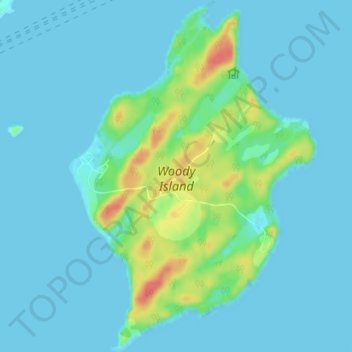
Name: Topografische Karte Woody Island, Höhe, Relief.
Ort: Woody Island, Kodiak Island, Alaska, United States (57.76023 -152.36161 57.79822 -152.31132)
Durchschnittliche Höhe: 9 m
Minimale Höhe: -5 m
Maximale Höhe: 53 m
Andere topografische Karten
Klicken Sie auf eine Karte, um ihre Topografie, ihre Höhe und ihr Relief anzuzeigen.
Raspberry Island
United States > Alaska > Kodiak Island
Raspberry Island, Kodiak Island, Alaska, United States
Durchschnittliche Höhe: 71 m
Trident Volcano
United States > Alaska > Kodiak Island
Trident Volcano, Kodiak Island, Alaska, United States
Durchschnittliche Höhe: 1.338 m
Mount Katmai
United States > Alaska > Kodiak Island
Mount Katmai, Kodiak Island, Alaska, United States
Durchschnittliche Höhe: 1.507 m
Kodiak
United States > Alaska > Kodiak Island
Kodiak, Kodiak Island, Alaska, United States
Durchschnittliche Höhe: 62 m