
Topografische Karte Xochimilco
Interaktive Karte
Klicken Sie auf die Karte, um die Höhe anzuzeigen.
Über diese Karte
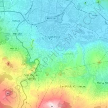
Name: Topografische Karte Xochimilco, Höhe, Relief.
Ort: Xochimilco, Mexico City, Mexico (19.15254 -99.15439 19.32045 -99.00704)
Durchschnittliche Höhe: 2.512 m
Minimale Höhe: 2.229 m
Maximale Höhe: 3.494 m
Much of the borough's land is former lakebed. Its main elevations include Xochitepec and Tlacualleli mountains along with two volcanoes named Teutli and Tzompol. It contains two natural rivers called Santiago and Tepapantla along with the various canals, which is what is left of the lake. The elevated areas of the borough contain small forests of ocotes, strawberry trees, cedars, Montezuma cypress and a tree called a “tepozan.”
Andere topografische Karten
Klicken Sie auf eine Karte, um ihre Topografie, ihre Höhe und ihr Relief anzuzeigen.
07860
07860, Gustavo A. Madero, Mexico City, Mexico
Durchschnittliche Höhe: 2.232 m
Parque España
Parque España, Condesa, Cuauhtémoc, Mexico City, 06140, Mexico
Durchschnittliche Höhe: 2.242 m
Island of the Dead Dolls
Island of the Dead Dolls, Xochimilco, Mexico City, 16043, Mexico
Durchschnittliche Höhe: 2.235 m
Parque Lira
Parque Lira, Mexico City, 11860, Mexico
Durchschnittliche Höhe: 2.271 m
Bosque de Chapultepec
Bosque de Chapultepec, Mexico City, 11590, Mexico
Durchschnittliche Höhe: 2.296 m