
Topografische Karte Benito Juárez
Interaktive Karte
Klicken Sie auf die Karte, um die Höhe anzuzeigen.
Über diese Karte
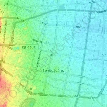
Name: Topografische Karte Benito Juárez, Höhe, Relief.
Ort: Benito Juárez, Mexico City, Mexico (19.35689 -99.19214 19.40406 -99.13094)
Durchschnittliche Höhe: 2.244 m
Minimale Höhe: 2.231 m
Maximale Höhe: 2.282 m
It has a territory of 26.63 km2 (2,661.5 hectares), which is 1.8% of Mexico City, with an average altitude of 2,242 metres. It consists of 56 neighborhoods called "colonias" and three major apartment complexes (unidades habitacionales) which cover 2,210 city blocks and through which some of the most important city thoroughfares pass. The borough is nearly entirely residential with a socioeconomic level of middle class to upper middle class.
Andere topografische Karten
Klicken Sie auf eine Karte, um ihre Topografie, ihre Höhe und ihr Relief anzuzeigen.
07860
07860, Gustavo A. Madero, Mexico City, Mexico
Durchschnittliche Höhe: 2.232 m
Parque España
Parque España, Condesa, Cuauhtémoc, Mexico City, 06140, Mexico
Durchschnittliche Höhe: 2.242 m
Island of the Dead Dolls
Island of the Dead Dolls, Xochimilco, Mexico City, 16043, Mexico
Durchschnittliche Höhe: 2.235 m
Parque Lira
Parque Lira, Mexico City, 11860, Mexico
Durchschnittliche Höhe: 2.271 m
Bosque de Chapultepec
Bosque de Chapultepec, Mexico City, 11590, Mexico
Durchschnittliche Höhe: 2.296 m