
Spenden
Rüsten Sie sich für Ihr nächstes Abenteuer:
Als Amazon-Partner erhält diese Website eine Provision für qualifizierte Käufe, ohne zusätzliche Kosten für Sie.
Topografische Karte Tumaco
Klicken Sie auf die Karte, um die Höhe anzuzeigen.
Spenden
Rüsten Sie sich für Ihr nächstes Abenteuer:
Als Amazon-Partner erhält diese Website eine Provision für qualifizierte Käufe, ohne zusätzliche Kosten für Sie.
Über diese Karte
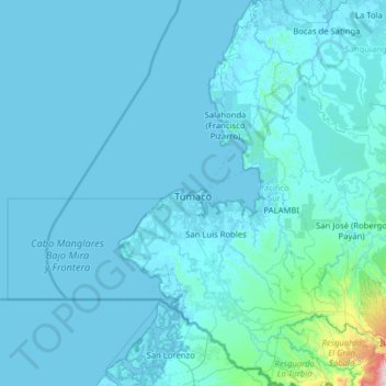
Name: Topografische Karte Tumaco, Höhe, Relief.
Ort: Tumaco, Pacífico Sur, Nariño, RAP Pacífico, Colombia (1.18750 -79.01066 2.45236 -78.25566)
Durchschnittliche Höhe: 50 m
Minimale Höhe: -4 m
Maximale Höhe: 1.863 m
Spenden
Rüsten Sie sich für Ihr nächstes Abenteuer:
Als Amazon-Partner erhält diese Website eine Provision für qualifizierte Käufe, ohne zusätzliche Kosten für Sie.
Andere topografische Karten
Klicken Sie auf eine Karte, um ihre Topografie, ihre Höhe und ihr Relief anzuzeigen.
Spenden
Rüsten Sie sich für Ihr nächstes Abenteuer:
Als Amazon-Partner erhält diese Website eine Provision für qualifizierte Käufe, ohne zusätzliche Kosten für Sie.
Galeras
Numerous minor tremors and ash emissions since March 2006 culminated on 12 July 2006 in three explosive eruptions, producing an ash and gas column reaching an altitude of 8 kilometres (5.0 mi). Rock falls and pyroclastic flows were reported from towns as distant as Consacá, 11.4 kilometres (7.1 mi) west of…
Durchschnittliche Höhe: 3.847 m
Spenden
Rüsten Sie sich für Ihr nächstes Abenteuer:
Als Amazon-Partner erhält diese Website eine Provision für qualifizierte Käufe, ohne zusätzliche Kosten für Sie.
Pasto
Colombia > Nariño > Pasto > Pasto
Most of the city lies between 2,520 metres (8,270 ft) and 2,700 metres (8,900 ft) elevation above sea level, while some settlement exceeds 3,000 metres (9,800 ft) on the flanks of the Galeras Volcano, which stands at 4,276 metres (14,029 ft).
Durchschnittliche Höhe: 2.668 m
Ipiales
Colombia > Nariño > Ipiales > Ipiales
Ipiales is a city and Catholic bishopric in Nariño Department, southern Colombia, near the border with Ecuador. It is located at around 0°49′49″N 77°38′40″W / 0.83028°N 77.64444°W / 0.83028; -77.64444, with an elevation of about 2950 m. Ipiales is located on the high plateau called…
Durchschnittliche Höhe: 2.881 m
Spenden
Rüsten Sie sich für Ihr nächstes Abenteuer:
Als Amazon-Partner erhält diese Website eine Provision für qualifizierte Käufe, ohne zusätzliche Kosten für Sie.
Azufral
Azufral is a stratovolcano located in the department of Nariño in southern Colombia, 12 km (7 mi) west of the town of Túquerres. It is the only volcano of the Western Ranges of the Colombian Andes. Its name derives from the Spanish word for sulfur, azufre. The volcano is considered semi-dormant but there are…
Durchschnittliche Höhe: 3.771 m