
Spenden
Rüsten Sie sich für Ihr nächstes Abenteuer:
Als Amazon-Partner erhält diese Website eine Provision für qualifizierte Käufe, ohne zusätzliche Kosten für Sie.
Topografische Karte Junín
Klicken Sie auf die Karte, um die Höhe anzuzeigen.
Spenden
Rüsten Sie sich für Ihr nächstes Abenteuer:
Als Amazon-Partner erhält diese Website eine Provision für qualifizierte Käufe, ohne zusätzliche Kosten für Sie.
Über diese Karte
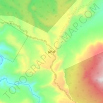
Name: Topografische Karte Junín, Höhe, Relief.
Ort: Junín, Barbacoas, Telembí, Nariño, RAP Pacífico, Colombia (1.29312 -78.15803 1.37312 -78.07803)
Durchschnittliche Höhe: 966 m
Minimale Höhe: 456 m
Maximale Höhe: 1.708 m
Spenden
Rüsten Sie sich für Ihr nächstes Abenteuer:
Als Amazon-Partner erhält diese Website eine Provision für qualifizierte Käufe, ohne zusätzliche Kosten für Sie.
Andere topografische Karten
Klicken Sie auf eine Karte, um ihre Topografie, ihre Höhe und ihr Relief anzuzeigen.
Pasto
Most of the city lies between 2,520 metres (8,270 ft) and 2,700 metres (8,900 ft) elevation above sea level, while some settlement exceeds 3,000 metres (9,800 ft) on the flanks of the Galeras Volcano, which stands at 4,276 metres (14,029 ft).
Durchschnittliche Höhe: 2.676 m
Spenden
Rüsten Sie sich für Ihr nächstes Abenteuer:
Als Amazon-Partner erhält diese Website eine Provision für qualifizierte Käufe, ohne zusätzliche Kosten für Sie.
Pasto
Colombia > Nariño > Pasto > Pasto
Most of the city lies between 2,520 metres (8,270 ft) and 2,700 metres (8,900 ft) elevation above sea level, while some settlement exceeds 3,000 metres (9,800 ft) on the flanks of the Galeras Volcano, which stands at 4,276 metres (14,029 ft).
Durchschnittliche Höhe: 2.668 m
Pasto
Most of the city lies between 2,520 metres (8,270 ft) and 2,700 metres (8,900 ft) elevation above sea level, while some settlement exceeds 3,000 metres (9,800 ft) on the flanks of the Galeras Volcano, which stands at 4,276 metres (14,029 ft).
Durchschnittliche Höhe: 2.676 m
Spenden
Rüsten Sie sich für Ihr nächstes Abenteuer:
Als Amazon-Partner erhält diese Website eine Provision für qualifizierte Käufe, ohne zusätzliche Kosten für Sie.