
Topografische Karte Tamworth
Interaktive Karte
Klicken Sie auf die Karte, um die Höhe anzuzeigen.
Über diese Karte
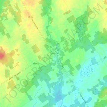
Name: Topografische Karte Tamworth, Höhe, Relief.
Durchschnittliche Höhe: 166 m
Minimale Höhe: 142 m
Maximale Höhe: 200 m
Andere topografische Karten
Klicken Sie auf eine Karte, um ihre Topografie, ihre Höhe und ihr Relief anzuzeigen.
Puzzle Lake Provincial Park
Canada > Ontario > Lennox and Addington County > Stone Mills
Puzzle Lake Provincial Park, Stone Mills, Lennox and Addington County, Eastern Ontario, Ontario, Canada
Durchschnittliche Höhe: 196 m
Newburgh
Canada > Ontario > Lennox and Addington County > Stone Mills
Newburgh, Stone Mills, Greater Napanee, Lennox and Addington County, Eastern Ontario, Ontario, K0K 2S0, Canada
Durchschnittliche Höhe: 129 m
Colebrook
Canada > Ontario > Lennox and Addington County > Stone Mills
Colebrook, Stone Mills, Lennox and Addington County, Eastern Ontario, Ontario, K0K 3N0, Canada
Durchschnittliche Höhe: 153 m
Erinsville
Canada > Ontario > Lennox and Addington County > Stone Mills
Erinsville, Stone Mills, Lennox and Addington County, Eastern Ontario, Ontario, K0K 2A0, Canada
Durchschnittliche Höhe: 174 m
Yarker
Canada > Ontario > Lennox and Addington County > Stone Mills
Yarker, Stone Mills, Lennox and Addington County, Eastern Ontario, Ontario, K0K 3N0, Canada
Durchschnittliche Höhe: 152 m
Moscow
Canada > Ontario > Lennox and Addington County > Stone Mills
Moscow, Stone Mills, Lennox and Addington County, Eastern Ontario, Ontario, Canada
Durchschnittliche Höhe: 146 m