
Spenden
Rüsten Sie sich für Ihr nächstes Abenteuer:
Als Amazon-Partner erhält diese Website eine Provision für qualifizierte Käufe, ohne zusätzliche Kosten für Sie.
Topografische Karte Colebrook
Klicken Sie auf die Karte, um die Höhe anzuzeigen.
Spenden
Rüsten Sie sich für Ihr nächstes Abenteuer:
Als Amazon-Partner erhält diese Website eine Provision für qualifizierte Käufe, ohne zusätzliche Kosten für Sie.
Über diese Karte
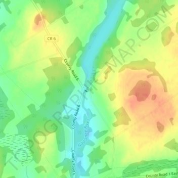
Name: Topografische Karte Colebrook, Höhe, Relief.
Durchschnittliche Höhe: 153 m
Minimale Höhe: 130 m
Maximale Höhe: 175 m
Spenden
Rüsten Sie sich für Ihr nächstes Abenteuer:
Als Amazon-Partner erhält diese Website eine Provision für qualifizierte Käufe, ohne zusätzliche Kosten für Sie.
Andere topografische Karten
Klicken Sie auf eine Karte, um ihre Topografie, ihre Höhe und ihr Relief anzuzeigen.
Puzzle Lake Provincial Park
Canada > Ontario > Lennox and Addington County > Stone Mills
Durchschnittliche Höhe: 196 m
Lions Beaver Lake Park
Canada > Ontario > Lennox and Addington County > Stone Mills > Erinsville
Durchschnittliche Höhe: 172 m
Carroll Lake
Canada > Ontario > Lennox and Addington County > Stone Mills
Durchschnittliche Höhe: 178 m
Napanee River
Canada > Ontario > Lennox and Addington County > Stone Mills
Durchschnittliche Höhe: 128 m
Spenden
Rüsten Sie sich für Ihr nächstes Abenteuer:
Als Amazon-Partner erhält diese Website eine Provision für qualifizierte Käufe, ohne zusätzliche Kosten für Sie.