
Topografische Karte Ardrossan
Interaktive Karte
Klicken Sie auf die Karte, um die Höhe anzuzeigen.
Über diese Karte
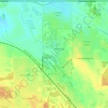
Name: Topografische Karte Ardrossan, Höhe, Relief.
Ort: Ardrossan, Strathcona County, Alberta, T8E 2A2, Canada (53.54849 -113.14785 53.56491 -113.13563)
Durchschnittliche Höhe: 710 m
Minimale Höhe: 695 m
Maximale Höhe: 727 m
Andere topografische Karten
Klicken Sie auf eine Karte, um ihre Topografie, ihre Höhe und ihr Relief anzuzeigen.
Hamlet of Antler Lake
Canada > Alberta > Strathcona County
Hamlet of Antler Lake, Strathcona County, Alberta, Canada
Durchschnittliche Höhe: 745 m
Hastings Lake
Canada > Alberta > Strathcona County
Hastings Lake, Strathcona County, Alberta, Canada
Durchschnittliche Höhe: 744 m
Hamlet of Josephburg
Canada > Alberta > Strathcona County > Hamlet of Josephburg
Hamlet of Josephburg, Strathcona County, Alberta, T8L 4B8, Canada
Durchschnittliche Höhe: 639 m
Cooking Lake
Canada > Alberta > Strathcona County
Cooking Lake, Strathcona County, Alberta, Canada
Durchschnittliche Höhe: 745 m