
Topografische Karte Hamlet of Antler Lake
Interaktive Karte
Klicken Sie auf die Karte, um die Höhe anzuzeigen.
Über diese Karte
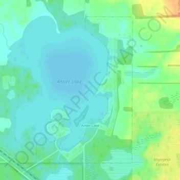
Name: Topografische Karte Hamlet of Antler Lake, Höhe, Relief.
Ort: Hamlet of Antler Lake, Strathcona County, Alberta, Canada (53.48295 -112.98830 53.50501 -112.96394)
Durchschnittliche Höhe: 745 m
Minimale Höhe: 735 m
Maximale Höhe: 769 m
Andere topografische Karten
Klicken Sie auf eine Karte, um ihre Topografie, ihre Höhe und ihr Relief anzuzeigen.
Hastings Lake
Canada > Alberta > Strathcona County
Hastings Lake, Strathcona County, Alberta, Canada
Durchschnittliche Höhe: 744 m
Hamlet of Josephburg
Canada > Alberta > Strathcona County > Hamlet of Josephburg
Hamlet of Josephburg, Strathcona County, Alberta, T8L 4B8, Canada
Durchschnittliche Höhe: 639 m
Ardrossan
Canada > Alberta > Strathcona County
Ardrossan, Strathcona County, Alberta, T8E 2A2, Canada
Durchschnittliche Höhe: 710 m
Cooking Lake
Canada > Alberta > Strathcona County
Cooking Lake, Strathcona County, Alberta, Canada
Durchschnittliche Höhe: 745 m