
Topografische Karte Municipality of Glyfada
Interaktive Karte
Klicken Sie auf die Karte, um die Höhe anzuzeigen.
Über diese Karte
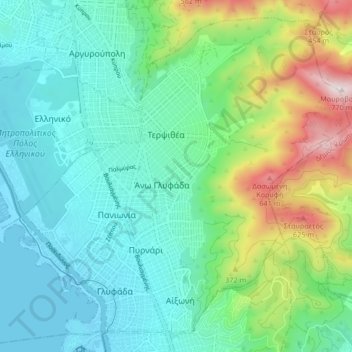
Name: Topografische Karte Municipality of Glyfada, Höhe, Relief.
Durchschnittliche Höhe: 195 m
Minimale Höhe: -11 m
Maximale Höhe: 773 m
Andere topografische Karten
Klicken Sie auf eine Karte, um ihre Topografie, ihre Höhe und ihr Relief anzuzeigen.
Palaio Faliro
Greece > Attica > Regional Unit of South Athens
Palaio Faliro, Municipality of Palaio Faliro, Regional Unit of South Athens, Attica, 175 61, Greece
Durchschnittliche Höhe: 27 m
Nea Smyrni
Greece > Attica > Regional Unit of South Athens
Nea Smyrni, Municipality of Nea Smyrni, Regional Unit of South Athens, Attica, 171 21, Greece
Durchschnittliche Höhe: 61 m
Municipality of Agios Dimitrios
Greece > Attica > Regional Unit of South Athens
Municipality of Agios Dimitrios, Regional Unit of South Athens, Attica, Greece
Durchschnittliche Höhe: 80 m
Municipality of Alimos
Greece > Attica > Regional Unit of South Athens
Municipality of Alimos, Regional Unit of South Athens, Attica, Greece
Durchschnittliche Höhe: 33 m
Municipal Unit of Moschato
Greece > Attica > Regional Unit of South Athens
Municipal Unit of Moschato, Municipality of Moschato-Tavros, Regional Unit of South Athens, Attica, Greece
Durchschnittliche Höhe: 11 m
Municipal Unit of Elliniko
Greece > Attica > Regional Unit of South Athens
Municipal Unit of Elliniko, Municipality of Elliniko - Argyroupoli, Regional Unit of South Athens, Attica, Greece
Durchschnittliche Höhe: 44 m