
Topografische Karte Palaio Faliro
Interaktive Karte
Klicken Sie auf die Karte, um die Höhe anzuzeigen.
Über diese Karte
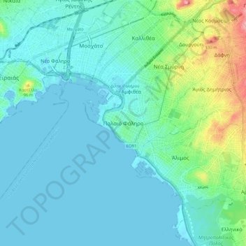
Name: Topografische Karte Palaio Faliro, Höhe, Relief.
Durchschnittliche Höhe: 27 m
Minimale Höhe: -5 m
Maximale Höhe: 148 m
Phaleron was an important place in antiquity, then as now one of the demes of Athens; however, a precise definition of its Classical topography is lacking, although the location of the deme is well established. Pausanias records that it was on the coast, equidistant from Athens and Cape Kolias (i.e., Ayios Kosmas) at 20 stadia. Strabo enumerates the coastal demes east of Piraeus and starts with Phaleron. The site of the ancient town appears to be the area and headland around the church of St. George, with the harbour to the west in the open roadstead. Remains of conglomerate blocks have been found crossing the heights of Old Phaleron to the sea and these are likely to be part of the Phaleric Wall recorded by Thucydides.
Andere topografische Karten
Klicken Sie auf eine Karte, um ihre Topografie, ihre Höhe und ihr Relief anzuzeigen.
Nea Smyrni
Greece > Attica > Regional Unit of South Athens
Nea Smyrni, Municipality of Nea Smyrni, Regional Unit of South Athens, Attica, 171 21, Greece
Durchschnittliche Höhe: 61 m
Municipality of Agios Dimitrios
Greece > Attica > Regional Unit of South Athens
Municipality of Agios Dimitrios, Regional Unit of South Athens, Attica, Greece
Durchschnittliche Höhe: 80 m
Municipality of Alimos
Greece > Attica > Regional Unit of South Athens
Municipality of Alimos, Regional Unit of South Athens, Attica, Greece
Durchschnittliche Höhe: 33 m
Municipality of Glyfada
Greece > Attica > Regional Unit of South Athens
Municipality of Glyfada, Regional Unit of South Athens, Attica, Greece
Durchschnittliche Höhe: 195 m
Municipal Unit of Moschato
Greece > Attica > Regional Unit of South Athens
Municipal Unit of Moschato, Municipality of Moschato-Tavros, Regional Unit of South Athens, Attica, Greece
Durchschnittliche Höhe: 11 m
Municipal Unit of Elliniko
Greece > Attica > Regional Unit of South Athens
Municipal Unit of Elliniko, Municipality of Elliniko - Argyroupoli, Regional Unit of South Athens, Attica, Greece
Durchschnittliche Höhe: 44 m