
Topografische Karte Dallas
Interaktive Karte
Klicken Sie auf die Karte, um die Höhe anzuzeigen.
Über diese Karte
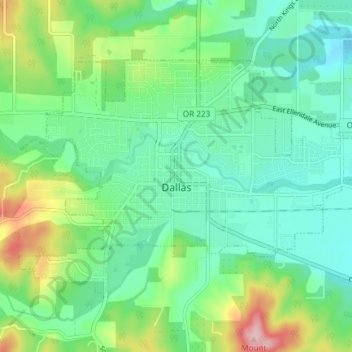
Name: Topografische Karte Dallas, Höhe, Relief.
Ort: Dallas, Polk County, Oregon, 97338, United States (44.90314 -123.34915 44.93801 -123.27495)
Durchschnittliche Höhe: 119 m
Minimale Höhe: 67 m
Maximale Höhe: 251 m
Dallas is along Rickreall Creek, about 15 miles (24 km) west of Salem, at an elevation of 325 feet (99 m) above sea level. It is part of the Salem Metropolitan Statistical Area.
Andere topografische Karten
Klicken Sie auf eine Karte, um ihre Topografie, ihre Höhe und ihr Relief anzuzeigen.
Willamette River
United States > Oregon > Polk County
Willamette River, Polk County, Oregon, United States
Durchschnittliche Höhe: 72 m
Monmouth
United States > Oregon > Polk County
Monmouth, Polk County, Oregon, United States
Durchschnittliche Höhe: 58 m
Buena Vista
United States > Oregon > Polk County
Buena Vista, Polk County, Oregon, United States
Durchschnittliche Höhe: 67 m
Aaron Mercer Reservoir
United States > Oregon > Polk County
Aaron Mercer Reservoir, Polk County, Oregon, United States
Durchschnittliche Höhe: 367 m
Independence
United States > Oregon > Polk County
Independence, Polk County, Oregon, 97351, United States
Durchschnittliche Höhe: 50 m
Grand Ronde
United States > Oregon > Polk County > Grand Ronde
Grand Ronde, Polk County, Oregon, United States
Durchschnittliche Höhe: 132 m