
Topografische Karte Aaron Mercer Reservoir
Interaktive Karte
Klicken Sie auf die Karte, um die Höhe anzuzeigen.
Über diese Karte
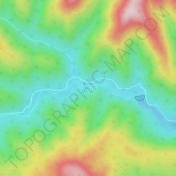
Name: Topografische Karte Aaron Mercer Reservoir, Höhe, Relief.
Ort: Aaron Mercer Reservoir, Polk County, Oregon, United States (44.90322 -123.48803 44.90658 -123.46958)
Durchschnittliche Höhe: 367 m
Minimale Höhe: 213 m
Maximale Höhe: 623 m
Andere topografische Karten
Klicken Sie auf eine Karte, um ihre Topografie, ihre Höhe und ihr Relief anzuzeigen.
Willamette River
United States > Oregon > Polk County
Willamette River, Polk County, Oregon, United States
Durchschnittliche Höhe: 72 m
Dallas
United States > Oregon > Polk County
Dallas, Polk County, Oregon, 97338, United States
Durchschnittliche Höhe: 119 m
Monmouth
United States > Oregon > Polk County
Monmouth, Polk County, Oregon, United States
Durchschnittliche Höhe: 58 m
Buena Vista
United States > Oregon > Polk County
Buena Vista, Polk County, Oregon, United States
Durchschnittliche Höhe: 67 m
Independence
United States > Oregon > Polk County
Independence, Polk County, Oregon, 97351, United States
Durchschnittliche Höhe: 50 m
Grand Ronde
United States > Oregon > Polk County > Grand Ronde
Grand Ronde, Polk County, Oregon, United States
Durchschnittliche Höhe: 132 m