
Topografische Karte Sitakunda Upazila
Interaktive Karte
Klicken Sie auf die Karte, um die Höhe anzuzeigen.
Über diese Karte
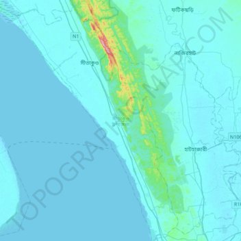
Name: Topografische Karte Sitakunda Upazila, Höhe, Relief.
Durchschnittliche Höhe: 15 m
Minimale Höhe: -1 m
Maximale Höhe: 304 m
Sitakunda Upazila occupies an area of 483.97 square kilometres (186.86 sq mi), which includes 61.61 square kilometres (23.79 sq mi) of forest. It is bordered by Mirsharai to the north, Pahartali to the south, Fatickchhari, Hathazari and Panchlaish to the east, and the Sandwip Channel in the Bay of Bengal to the west. The Sitakunda range is a 32-kilometre (20 mi) long ridge in the center of the upazila, which reaches an altitude of 352 metres (1,155 ft) above sea level at Chandranath or Sitakunda peak, the highest peak in Chittagong District. Part of Sitakunda is covered by the low hill ranges, while the rest is in the Bengal flood plain. To the north, Rajbari Tila at 274 metres (899 ft) and Sajidhala at 244 metres (801 ft) are the highest peaks in this range, which drops abruptly to a height of less than 92 metres (302 ft) in the vicinity of Chittagong City to the south. About 5 kilometres (3 mi) north of Sitakunda Town is the Labanakhya saltwater hot spring, which has been proposed as a source of geothermal energy. There are two waterfalls in the hills: Sahasradhara (thousand streams) and Suptadhara (hidden stream). Both have been identified as sites requiring special attention for protection and preservation by the National Heritage Foundation of Bangladesh.
Andere topografische Karten
Klicken Sie auf eine Karte, um ihre Topografie, ihre Höhe und ihr Relief anzuzeigen.
Rajeshpur Eco-Park
Bangladesh > Chattogram Division > Cumilla Adarsha Sadar Upazila
Rajeshpur Eco-Park, Cumilla Adarsha Sadar Upazila, Cumilla District, Chattogram Division, Bangladesh
Durchschnittliche Höhe: 15 m
Ujirpur
Bangladesh > Chattogram Division > Chauddagram Upazila
Ujirpur, Chauddagram Upazila, Cumilla District, Chattogram Division, 3504, Bangladesh
Durchschnittliche Höhe: 13 m
Lalmai
Bangladesh > Chattogram Division > Cumilla Adarsha Sadar Upazila
Lalmai, Cumilla Adarsha Sadar Upazila, Cumilla District, Chattogram Division, Bangladesh
Durchschnittliche Höhe: 14 m
Mirsharai
Bangladesh > Chattogram Division
Mirsharai, Chattogram District, Chattogram Division, Bangladesh
Durchschnittliche Höhe: 21 m
Khagrachhari
Bangladesh > Chattogram Division > Khagrachhari Sadar Upazila
Khagrachhari, Khagrachhari Sadar Upazila, Khagrachari Hill District, Chattogram Division, 4400, Bangladesh
Durchschnittliche Höhe: 82 m
Manikchari
Bangladesh > Chattogram Division > Manikchhari Upazila
Manikchari, Manikchhari Upazila, Khagrachari Hill District, Chattogram Division, Bangladesh
Durchschnittliche Höhe: 42 m
Rangamati
Bangladesh > Chattogram Division > Rangamati Sadar Upazila
Rangamati, Rangamati Sadar Upazila, Rangamati Hill District, Chattogram Division, 0351, Bangladesh
Durchschnittliche Höhe: 68 m
Sitakunda
Bangladesh > Chattogram Division > Sitakunda Upazila
Sitakunda, Sitakunda Upazila, Chattogram District, Chattogram Division, Bangladesh
Durchschnittliche Höhe: 40 m
Bakkhali River
Bangladesh > Chattogram Division > Sinaipara
Bakkhali River, Sinaipara, Bandarban Hill District, Chattogram Division, Bangladesh
Durchschnittliche Höhe: 91 m
Feni District
Bangladesh > Chattogram Division
Feni District, Chattogram Division, Bangladesh
Durchschnittliche Höhe: 19 m
Mirzapur
Bangladesh > Chattogram Division > Chandpur Sadar Upazila
Mirzapur, Chandpur Sadar Upazila, Chandpur District, Chattogram Division, 3602, Bangladesh
Durchschnittliche Höhe: 9 m
Thanchi Upazila
Bangladesh > Chattogram Division
Thanchi Upazila, Bandarban Hill District, Chattogram Division, Bangladesh
Durchschnittliche Höhe: 192 m
Chittagong District
Bangladesh > Chattogram Division
Chittagong District, Chattogram Division, Bangladesh
Durchschnittliche Höhe: 2 m
Bandarban
Bangladesh > Chattogram Division
Bandarban, Bandarban Hill District, Chattogram Division, Bangladesh
Durchschnittliche Höhe: 78 m
Chattogram District
Bangladesh > Chattogram Division
Chattogram District, Chattogram Division, Bangladesh
Durchschnittliche Höhe: 28 m
Rangamati
Bangladesh > Chattogram Division
Rangamati, Rangamati Hill District, Chattogram Division, 0351, Bangladesh
Durchschnittliche Höhe: 71 m
Burichang
Bangladesh > Chattogram Division > Burichang Upazila
Burichang, Burichang Upazila, Cumilla District, Chattogram Division, Bangladesh
Durchschnittliche Höhe: 8 m
Bhingra
Bangladesh > Chattogram Division > Shaharasti Upazila > Bhingra
Bhingra, Shaharasti Upazila, Chandpur District, Chattogram Division, 3620, Bangladesh
Durchschnittliche Höhe: 7 m
Sonadia Island
Bangladesh > Chattogram Division > Cox's Bazar District > Poschim para > Sonadia Island
Sonadia Island, Poschim para, Cox's Bazar District, Chattogram Division, Bangladesh
Durchschnittliche Höhe: 1 m
Chattogram
Bangladesh > Chattogram Division
Chattogram, Chattogram District, Chattogram Division, 4000, Bangladesh
Durchschnittliche Höhe: 6 m
Bandarban Hill District
Bangladesh > Chattogram Division
Bandarban Hill District, Chattogram Division, Bangladesh
Durchschnittliche Höhe: 190 m
Keokradong
Bangladesh > Chattogram Division > Bandarban District > Darjeling para
Keokradong, Darjeling para, Bandarban District, Chattogram Division, Bangladesh
Durchschnittliche Höhe: 747 m
Darjeling para
Bangladesh > Chattogram Division > Bandarban District > Darjeling para
Darjeling para, Bandarban District, Chattogram Division, Bangladesh
Durchschnittliche Höhe: 616 m
Ramu
Bangladesh > Chattogram Division > Cox's Bazar District > Ramu
Ramu, Cox's Bazar District, Chattogram Division, Bangladesh
Durchschnittliche Höhe: 10 m
Chattogram
Bangladesh > Chattogram Division > Chattogram
Chattogram, Chattogram District, Chattogram Division, 4000, Bangladesh
Durchschnittliche Höhe: 6 m
DC Hill
Bangladesh > Chattogram Division > Chattogram
DC Hill, Chattogram, Chattogram District, Chattogram Division, Bangladesh
Durchschnittliche Höhe: 14 m
Ashuganj Bazar
Bangladesh > Chattogram Division > Ashuganj Bazar
Ashuganj Bazar, Brahmanbaria District, Chattogram Division, Bangladesh
Durchschnittliche Höhe: 6 m
Cumilla
Bangladesh > Chattogram Division > Cumilla Adarsha Sadar Upazila
Cumilla, Cumilla Adarsha Sadar Upazila, Cumilla District, Chattogram Division, 3500, Bangladesh
Durchschnittliche Höhe: 16 m
Chandpur District
Bangladesh > Chattogram Division
Chandpur District, Chattogram Division, Bangladesh
Durchschnittliche Höhe: 6 m
Bandarban
Bangladesh > Chattogram Division > Bandarban
Bandarban, Bandarban District, Chattogram Division, Bangladesh
Durchschnittliche Höhe: 67 m
হাটহাজারী
Bangladesh > Chattogram Division > হাটহাজারী
হাটহাজারী, Chattogram District, Chattogram Division, 4331, Bangladesh
Durchschnittliche Höhe: 12 m
Chaktai khal
Bangladesh > Chattogram Division > Chattogram
Chaktai khal, Chattogram, Chattogram District, Chattogram Division, 4000, Bangladesh
Durchschnittliche Höhe: 11 m
Ruma
Bangladesh > Chattogram Division > Bandarban District > Ruma
Ruma, Bandarban District, Chattogram Division, Bangladesh
Durchschnittliche Höhe: 138 m
Rangamati Hill District
Bangladesh > Chattogram Division
Rangamati Hill District, Chattogram Division, Bangladesh
Durchschnittliche Höhe: 276 m
Capital
Bangladesh > Chattogram Division
Capital, Bandarban District, Chattogram Division, Bangladesh
Durchschnittliche Höhe: 664 m
Chandpur
Bangladesh > Chattogram Division > Chandpur
Chandpur, Chandpur District, Chattogram Division, 3601, Bangladesh
Durchschnittliche Höhe: 5 m
Kaptai Lake
Bangladesh > Chattogram Division
Kaptai Lake, Rangamati Hill District, Chattogram Division, Bangladesh
Durchschnittliche Höhe: 102 m