
Topografische Karte Rangamati
Interaktive Karte
Klicken Sie auf die Karte, um die Höhe anzuzeigen.
Über diese Karte
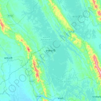
Name: Topografische Karte Rangamati, Höhe, Relief.
Durchschnittliche Höhe: 68 m
Minimale Höhe: 5 m
Maximale Höhe: 565 m
Rangamati (Bengali: রাঙ্গামাটি;) is the administrative headquarter and town of Rangamati Hill District in the Chittagong Hill Tracts of Bangladesh. The town is located at 22°37'60N 92°12'0E and has an altitude of 14 metres (46 ft).