
Topografische Karte Romagnano Sesia
Interaktive Karte
Klicken Sie auf die Karte, um die Höhe anzuzeigen.
Über diese Karte
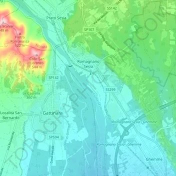
Name: Topografische Karte Romagnano Sesia, Höhe, Relief.
Ort: Romagnano Sesia, Novara, Piedmont, 28078, Italy (45.59247 8.34652 45.65284 8.43248)
Durchschnittliche Höhe: 293 m
Minimale Höhe: 235 m
Maximale Höhe: 527 m
Andere topografische Karten
Klicken Sie auf eine Karte, um ihre Topografie, ihre Höhe und ihr Relief anzuzeigen.
Fontaneto d'Agogna
Fontaneto d'Agogna, Novara, Piedmont, Italy
Durchschnittliche Höhe: 282 m
Pettenasco
Pettenasco, Novara, Piedmont, 28028, Italy
Durchschnittliche Höhe: 446 m