
Topografische Karte Fontaneto d'Agogna
Interaktive Karte
Klicken Sie auf die Karte, um die Höhe anzuzeigen.
Über diese Karte
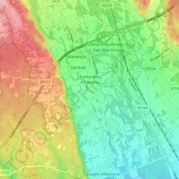
Name: Topografische Karte Fontaneto d'Agogna, Höhe, Relief.
Ort: Fontaneto d'Agogna, Novara, Piedmont, Italy (45.61211 8.42652 45.66820 8.50843)
Durchschnittliche Höhe: 282 m
Minimale Höhe: 236 m
Maximale Höhe: 352 m
Andere topografische Karten
Klicken Sie auf eine Karte, um ihre Topografie, ihre Höhe und ihr Relief anzuzeigen.
Pettenasco
Pettenasco, Novara, Piedmont, 28028, Italy
Durchschnittliche Höhe: 446 m
Romagnano Sesia
Romagnano Sesia, Novara, Piedmont, 28078, Italy
Durchschnittliche Höhe: 293 m