
Topografische Karte Hopewell
Interaktive Karte
Klicken Sie auf die Karte, um die Höhe anzuzeigen.
Über diese Karte
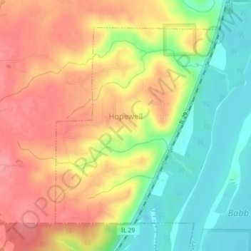
Name: Topografische Karte Hopewell, Höhe, Relief.
Ort: Hopewell, Marshall County, Illinois, United States (40.97322 -89.46737 40.99431 -89.44422)
Durchschnittliche Höhe: 177 m
Minimale Höhe: 132 m
Maximale Höhe: 215 m
Andere topografische Karten
Klicken Sie auf eine Karte, um ihre Topografie, ihre Höhe und ihr Relief anzuzeigen.
Wenona
United States > Illinois > Marshall County
Wenona, Marshall County, Illinois, 61377, United States
Durchschnittliche Höhe: 214 m
Varna
United States > Illinois > Marshall County
Varna, Marshall County, Illinois, United States
Durchschnittliche Höhe: 220 m
Marshall State Fish and Wildlife Area
United States > Illinois > Marshall County
Marshall State Fish and Wildlife Area, Marshall County, Illinois, United States
Durchschnittliche Höhe: 170 m
Lacon
United States > Illinois > Marshall County
Lacon, Marshall County, Illinois, United States
Durchschnittliche Höhe: 148 m