
Topografische Karte Eagle Mountain
Interaktive Karte
Klicken Sie auf die Karte, um die Höhe anzuzeigen.
Über diese Karte
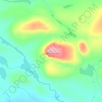
Name: Topografische Karte Eagle Mountain, Höhe, Relief.
Ort: Eagle Mountain, Cook County, Minnesota, United States (47.89737 -90.56039 47.89747 -90.56029)
Durchschnittliche Höhe: 596 m
Minimale Höhe: 545 m
Maximale Höhe: 697 m
Eagle Mountain is only about 15 miles (24 km) from Minnesota's lowest elevation, Lake Superior, at 600 feet (183 m). It is part of the Canadian Shield. Confusingly, there is another much shorter peak also named Eagle Mountain in northern Minnesota. The shorter peak is part of the Lutsen Mountains ski resort.
Andere topografische Karten
Klicken Sie auf eine Karte, um ihre Topografie, ihre Höhe und ihr Relief anzuzeigen.
West Cook
United States > Minnesota > Cook County
West Cook, Cook County, Minnesota, 55604, United States
Durchschnittliche Höhe: 501 m
Schroeder Township
United States > Minnesota > Cook County
Schroeder Township, Cook County, Minnesota, United States, Magic Lake
Durchschnittliche Höhe: 564 m
Tent Lake
United States > Minnesota > Cook County
Tent Lake, Cook County, Minnesota, United States
Durchschnittliche Höhe: 569 m
Fan Lake
United States > Minnesota > Cook County
Fan Lake, Cook County, Minnesota, United States
Durchschnittliche Höhe: 535 m
Lutsen
United States > Minnesota > Cook County
Lutsen, Cook County, Minnesota, 55612, United States
Durchschnittliche Höhe: 225 m
Olso Lake
United States > Minnesota > Cook County
Olso Lake, West Cook, Cook County, Minnesota, United States
Durchschnittliche Höhe: 544 m
Grand Marais
United States > Minnesota > Cook County
Grand Marais, Cook County, Minnesota, United States
Durchschnittliche Höhe: 280 m