
Topografische Karte Tent Lake
Interaktive Karte
Klicken Sie auf die Karte, um die Höhe anzuzeigen.
Über diese Karte
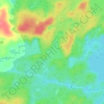
Name: Topografische Karte Tent Lake, Höhe, Relief.
Ort: Tent Lake, Cook County, Minnesota, United States (47.95410 -90.83975 47.95785 -90.83182)
Durchschnittliche Höhe: 569 m
Minimale Höhe: 543 m
Maximale Höhe: 609 m
Andere topografische Karten
Klicken Sie auf eine Karte, um ihre Topografie, ihre Höhe und ihr Relief anzuzeigen.
West Cook
United States > Minnesota > Cook County
West Cook, Cook County, Minnesota, 55604, United States
Durchschnittliche Höhe: 501 m
Schroeder Township
United States > Minnesota > Cook County
Schroeder Township, Cook County, Minnesota, United States, Magic Lake
Durchschnittliche Höhe: 564 m
Fan Lake
United States > Minnesota > Cook County
Fan Lake, Cook County, Minnesota, United States
Durchschnittliche Höhe: 535 m
Eagle Mountain
United States > Minnesota > Cook County
Eagle Mountain, Cook County, Minnesota, United States
Durchschnittliche Höhe: 596 m
Lutsen
United States > Minnesota > Cook County
Lutsen, Cook County, Minnesota, 55612, United States
Durchschnittliche Höhe: 225 m
Olso Lake
United States > Minnesota > Cook County
Olso Lake, West Cook, Cook County, Minnesota, United States
Durchschnittliche Höhe: 544 m
Grand Marais
United States > Minnesota > Cook County
Grand Marais, Cook County, Minnesota, United States
Durchschnittliche Höhe: 280 m