
Topografische Karte Poonjar
Interaktive Karte
Klicken Sie auf die Karte, um die Höhe anzuzeigen.
Über diese Karte
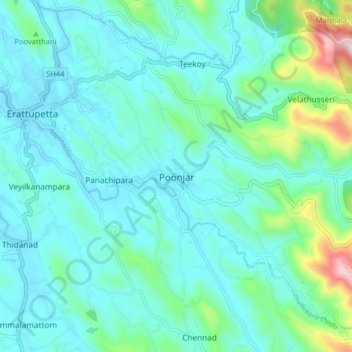
Name: Topografische Karte Poonjar, Höhe, Relief.
Ort: Poonjar, Meenachil, Kottayam District, Kerala, 686581, India (9.63376 76.77303 9.71376 76.85303)
Durchschnittliche Höhe: 123 m
Minimale Höhe: 17 m
Maximale Höhe: 651 m
Andere topografische Karten
Klicken Sie auf eine Karte, um ihre Topografie, ihre Höhe und ihr Relief anzuzeigen.
Kozhikombu
Kozhikombu, Meenachil, Kottayam District, Kerala, 686635, India
Durchschnittliche Höhe: 47 m
Marangattupilly
Marangattupilly, Meenachil, Kottayam, Kerala, 686635, India
Durchschnittliche Höhe: 63 m
Idappadi (edappady)
India > Kerala > Meenachil > Idappadi (edappady)
Idappadi (edappady), Meenachil, Kottayam, Kerala, 686578, India
Durchschnittliche Höhe: 44 m
Palachuvad Junction
India > Kerala > Meenachil > Palachuvad Junction
Palachuvad Junction, Meenachil, Kottayam, Kerala, 6, India
Durchschnittliche Höhe: 121 m