Geolokalisieren

Topografische Karte Pala

Interaktive Karte

Klicken Sie auf die Karte, um die Höhe anzuzeigen.

Über diese Karte

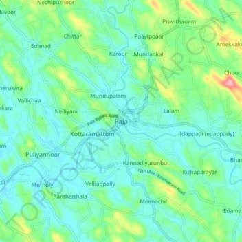
Name: Topografische Karte Pala, Höhe, Relief.

Ort: Pala, Meenachil, Kottayam District, Kerala, 686575, India (9.67307 76.64313 9.75307 76.72313)

Durchschnittliche Höhe: 40 m

Minimale Höhe: 5 m

Maximale Höhe: 161 m

Andere topografische Karten

Klicken Sie auf eine Karte, um ihre Topografie, ihre Höhe und ihr Relief anzuzeigen.

Kozhikombu

India > Kerala > Meenachil

Kozhikombu, Meenachil, Kottayam District, Kerala, 686635, India

Durchschnittliche Höhe: 47 m

Poonjar

India > Kerala > Meenachil

Poonjar, Meenachil, Kottayam District, Kerala, 686581, India

Durchschnittliche Höhe: 123 m

Marangattupilly

India > Kerala > Meenachil

Marangattupilly, Meenachil, Kottayam, Kerala, 686635, India

Durchschnittliche Höhe: 63 m

Andoor

India > Kerala > Meenachil > Andoor

Andoor, Meenachil, Kottayam, Kerala, 686635, India

Durchschnittliche Höhe: 51 m

Idappadi (edappady)

India > Kerala > Meenachil > Idappadi (edappady)

Idappadi (edappady), Meenachil, Kottayam, Kerala, 686578, India

Durchschnittliche Höhe: 44 m

Palachuvad Junction

India > Kerala > Meenachil > Palachuvad Junction

Palachuvad Junction, Meenachil, Kottayam, Kerala, 6, India

Durchschnittliche Höhe: 121 m

Mutholy

India > Kerala > Meenachil > Mutholi

Mutholy, Kottaramattom, Mutholi, Meenachil, Kottayam, Kerala, India

Durchschnittliche Höhe: 27 m