
Topografische Karte Brooklyn Bridge Park
Interaktive Karte
Klicken Sie auf die Karte, um die Höhe anzuzeigen.
Über diese Karte
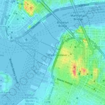
Name: Topografische Karte Brooklyn Bridge Park, Höhe, Relief.
Durchschnittliche Höhe: 9 m
Minimale Höhe: -6 m
Maximale Höhe: 56 m
Brooklyn Bridge Park spans 85 acres (34 ha) of the East River waterfront in the Brooklyn Heights and Dumbo neighborhoods of Brooklyn. The park is divided into eleven sections: Piers 1 through 6; Fulton Ferry Landing; Brooklyn Bridge Plaza; Empire Fulton Ferry; Main Street; and John Street. Each of these sections features unique topographies, plantings, amenities, and cultural artifacts and installations, and the Brooklyn–Queens Greenway spans the park, as does the Brooklyn Waterfront Greenway.
Andere topografische Karten
Klicken Sie auf eine Karte, um ihre Topografie, ihre Höhe und ihr Relief anzuzeigen.
Manhattan
United States > New York > New York County > New York
Manhattan, New York County, New York, United States
Durchschnittliche Höhe: 16 m
Central Park
United States > New York > New York County > New York
Central Park, New York County, New York, United States
Durchschnittliche Höhe: 26 m
Roosevelt Island
United States > New York > New York County > New York
Roosevelt Island, Manhattan, New York County, New York, 10044, United States
Durchschnittliche Höhe: 13 m
Battery Park
United States > New York > New York County > New York
Battery Park, Manhattan Community Board 1, Manhattan, New York County, New York, 10004, United States
Durchschnittliche Höhe: 3 m
Sara D. Roosevelt Park
United States > New York > New York County > New York
Sara D. Roosevelt Park, Lower East Side, Manhattan, New York County, New York, United States
Durchschnittliche Höhe: 14 m
Paley Park
United States > New York > New York County > New York
Paley Park, Midtown East, Manhattan, New York County, New York, 10022, United States
Durchschnittliche Höhe: 24 m
Liberty Island
United States > New York > New York County > New York
Liberty Island, Manhattan Community Board 1, Manhattan, New York County, New York, Hudson County, New York, United States
Durchschnittliche Höhe: 0 m
Fort Tryon Park
United States > New York > New York County > New York
Fort Tryon Park, Manhattan, New York County, New York, United States
Durchschnittliche Höhe: 20 m
Morningside Park
United States > New York > New York County > New York
Morningside Park, Morningside Heights, Manhattan, New York County, New York, United States
Durchschnittliche Höhe: 20 m
Bennett Park
United States > New York > New York County > New York
Bennett Park, Hudson Heights, Manhattan, New York County, New York, United States
Durchschnittliche Höhe: 24 m
Hunter’s Point South Waterfront Park
United States > New York > New York County > New York
Hunter’s Point South Waterfront Park, Manhattan Community Board 6, Manhattan, New York County, New York, United States
Durchschnittliche Höhe: 5 m
Teardrop Park
United States > New York > New York County > New York
Teardrop Park, Manhattan Community Board 1, Manhattan, New York County, New York, United States
Durchschnittliche Höhe: 6 m
Governors Island
United States > New York > New York County > New York
Governors Island, Manhattan, New York County, New York, United States
Durchschnittliche Höhe: 1 m
Sherman Square
United States > New York > New York County > New York
Sherman Square, Manhattan Community Board 7, Manhattan, New York County, New York, United States
Durchschnittliche Höhe: 22 m
Highbridge Park
United States > New York > New York County > New York
Highbridge Park, Manhattan, New York County, New York, United States
Durchschnittliche Höhe: 30 m