
Topografische Karte Lake Texoma
Interaktive Karte
Klicken Sie auf die Karte, um die Höhe anzuzeigen.
Über diese Karte
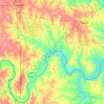
Name: Topografische Karte Lake Texoma, Höhe, Relief.
Ort: Lake Texoma, Marshall County, Oklahoma, United States (33.71228 -97.06889 34.16391 -96.51384)
Durchschnittliche Höhe: 213 m
Minimale Höhe: 148 m
Maximale Höhe: 308 m
Normal elevation of the conservation pool varies from 615 to 619 ft (187 to 189 m) National Geodetic Vertical Datum (NGVD) depending on the time of year. The flood control pool extends to elevation 645 ft (197 m) NGVD. The lake has crested the dam's spillway at a height of 640 ft (200 m) five times: once in 1957, again in 1990, 2007, May 24, 2015, and most recently on June 18, 2015. (USACE 2003a) The lake's previously highest elevation was recorded on May 6, 1990, at 644.76 feet. This record was broken on May 29, 2015, and the lake crested on June 1, 2015, at a new record elevation of 645.72 feet. The top of Denison Dam is at 670 feet.
Andere topografische Karten
Klicken Sie auf eine Karte, um ihre Topografie, ihre Höhe und ihr Relief anzuzeigen.
Antioch
United States > Oklahoma > Marshall County
Antioch, Marshall County, Oklahoma, United States
Durchschnittliche Höhe: 269 m
Kingston
United States > Oklahoma > Marshall County
Kingston, Marshall County, Oklahoma, United States
Durchschnittliche Höhe: 239 m
Madill
United States > Oklahoma > Marshall County
Madill, Marshall County, Oklahoma, 73446, United States
Durchschnittliche Höhe: 248 m
Cumberland
United States > Oklahoma > Marshall County > Cumberland
Cumberland, Marshall County, Oklahoma, United States
Durchschnittliche Höhe: 212 m