
Topografische Karte Kingston
Interaktive Karte
Klicken Sie auf die Karte, um die Höhe anzuzeigen.
Über diese Karte
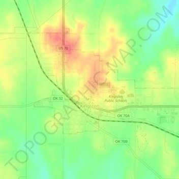
Name: Topografische Karte Kingston, Höhe, Relief.
Ort: Kingston, Marshall County, Oklahoma, United States (33.98954 -96.73469 34.01380 -96.69164)
Durchschnittliche Höhe: 239 m
Minimale Höhe: 208 m
Maximale Höhe: 272 m
Andere topografische Karten
Klicken Sie auf eine Karte, um ihre Topografie, ihre Höhe und ihr Relief anzuzeigen.
Lake Texoma
United States > Oklahoma > Marshall County
Lake Texoma, Marshall County, Oklahoma, United States
Durchschnittliche Höhe: 213 m
Antioch
United States > Oklahoma > Marshall County
Antioch, Marshall County, Oklahoma, United States
Durchschnittliche Höhe: 269 m
Madill
United States > Oklahoma > Marshall County
Madill, Marshall County, Oklahoma, 73446, United States
Durchschnittliche Höhe: 248 m
Cumberland
United States > Oklahoma > Marshall County > Cumberland
Cumberland, Marshall County, Oklahoma, United States
Durchschnittliche Höhe: 212 m