
Spenden
Rüsten Sie sich für Ihr nächstes Abenteuer:
Als Amazon-Partner erhält diese Website eine Provision für qualifizierte Käufe, ohne zusätzliche Kosten für Sie.
Topografische Karte Axe Edge Moor
Klicken Sie auf die Karte, um die Höhe anzuzeigen.
Spenden
Rüsten Sie sich für Ihr nächstes Abenteuer:
Als Amazon-Partner erhält diese Website eine Provision für qualifizierte Käufe, ohne zusätzliche Kosten für Sie.
Über diese Karte
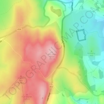
Name: Topografische Karte Axe Edge Moor, Höhe, Relief.
Durchschnittliche Höhe: 457 m
Minimale Höhe: 361 m
Maximale Höhe: 552 m
Spenden
Rüsten Sie sich für Ihr nächstes Abenteuer:
Als Amazon-Partner erhält diese Website eine Provision für qualifizierte Käufe, ohne zusätzliche Kosten für Sie.
Andere topografische Karten
Klicken Sie auf eine Karte, um ihre Topografie, ihre Höhe und ihr Relief anzuzeigen.
Buxton
United Kingdom > England > Derbyshire > High Peak
Buxton has an oceanic climate with short, mild summers and long, cool winters. At about 1,000 feet (300 m) above sea level, As the highest market town in England, Buxton's elevation makes it cooler and wetter than surrounding towns, with a daytime temperature typically about 2 °C lower than Manchester.
Durchschnittliche Höhe: 334 m
Spenden
Rüsten Sie sich für Ihr nächstes Abenteuer:
Als Amazon-Partner erhält diese Website eine Provision für qualifizierte Käufe, ohne zusätzliche Kosten für Sie.
New Mills
United Kingdom > England > Derbyshire > High Peak
High Peak Borough Council have produced a Conservation Area Character Appraisal document, outlining the reasons that the Conservation Area has been designated as such. In justifying the reasons for designation, this document states of the town: "New Mills is a town of dramatic topography and origins that date…
Durchschnittliche Höhe: 251 m
Spenden
Rüsten Sie sich für Ihr nächstes Abenteuer:
Als Amazon-Partner erhält diese Website eine Provision für qualifizierte Käufe, ohne zusätzliche Kosten für Sie.
Crowden Great Brook
United Kingdom > England > Derbyshire > High Peak > Tintwistle > Crowden
Durchschnittliche Höhe: 314 m
Spenden
Rüsten Sie sich für Ihr nächstes Abenteuer:
Als Amazon-Partner erhält diese Website eine Provision für qualifizierte Käufe, ohne zusätzliche Kosten für Sie.
Whaley Bridge
United Kingdom > England > Derbyshire > High Peak > Buxworth
Durchschnittliche Höhe: 266 m
Spenden
Rüsten Sie sich für Ihr nächstes Abenteuer:
Als Amazon-Partner erhält diese Website eine Provision für qualifizierte Käufe, ohne zusätzliche Kosten für Sie.
Bamford Edge
United Kingdom > England > Derbyshire > High Peak > Bamford
Durchschnittliche Höhe: 289 m
Kinder Scout National Nature Reserve
United Kingdom > England > Derbyshire > High Peak > Hayfield
Durchschnittliche Höhe: 513 m
Chisworth
United Kingdom > England > Derbyshire > High Peak > Higher Chisworth
Durchschnittliche Höhe: 218 m
Spenden
Rüsten Sie sich für Ihr nächstes Abenteuer:
Als Amazon-Partner erhält diese Website eine Provision für qualifizierte Käufe, ohne zusätzliche Kosten für Sie.
Derwent
United Kingdom > England > Derbyshire > High Peak > Bamford > Yorkshire Bridge
Durchschnittliche Höhe: 287 m
Crowden Great Brook
United Kingdom > England > Derbyshire > High Peak > Tintwistle
Durchschnittliche Höhe: 459 m
Spenden
Rüsten Sie sich für Ihr nächstes Abenteuer:
Als Amazon-Partner erhält diese Website eine Provision für qualifizierte Käufe, ohne zusätzliche Kosten für Sie.
Peak Forest
United Kingdom > England > Derbyshire > High Peak > Peak Forest
Durchschnittliche Höhe: 374 m
Derwent
United Kingdom > England > Derbyshire > High Peak > Bamford > Yorkshire Bridge
Durchschnittliche Höhe: 291 m
Spenden
Rüsten Sie sich für Ihr nächstes Abenteuer:
Als Amazon-Partner erhält diese Website eine Provision für qualifizierte Käufe, ohne zusätzliche Kosten für Sie.
Derwent
United Kingdom > England > Derbyshire > High Peak > Bamford > Yorkshire Bridge
Durchschnittliche Höhe: 293 m
Whaley Bridge
United Kingdom > England > Derbyshire > High Peak > Buxworth
Durchschnittliche Höhe: 262 m
New Mills
United Kingdom > England > Derbyshire > High Peak
High Peak Borough Council have produced a Conservation Area Character Appraisal document, outlining the reasons that the Conservation Area has been designated as such. In justifying the reasons for designation, this document states of the town: "New Mills is a town of dramatic topography and origins that date…
Durchschnittliche Höhe: 229 m
Spenden
Rüsten Sie sich für Ihr nächstes Abenteuer:
Als Amazon-Partner erhält diese Website eine Provision für qualifizierte Käufe, ohne zusätzliche Kosten für Sie.
Chapel-en-le-Frith
United Kingdom > England > Derbyshire > High Peak
In the rolling hills between Combs and Chapel is Bank Hall, extensively altered in 1872–74 for Henry Renshaw of Manchester on an ornate aerial plan with an elaborate stone balcony over the door, a bay window with fine botanical painted glass and canvas panels to the doors, formerly with painted panels by…
Durchschnittliche Höhe: 324 m
Buxton
United Kingdom > England > Derbyshire > High Peak
Buxton has an oceanic climate with short, mild summers and long, cool winters. At about 1,000 feet (300 m) above sea level, Buxton is the highest market town in England. Buxton's elevation makes it cooler and wetter than surrounding towns, with a daytime temperature typically about 2 °C lower than Manchester.
Durchschnittliche Höhe: 334 m
Spenden
Rüsten Sie sich für Ihr nächstes Abenteuer:
Als Amazon-Partner erhält diese Website eine Provision für qualifizierte Käufe, ohne zusätzliche Kosten für Sie.
Chapel-en-le-Frith
United Kingdom > England > Derbyshire > High Peak
In the rolling hills between Combs and Chapel is Bank Hall, extensively altered in 1872–74 for Henry Renshaw of Manchester on an ornate aerial plan with an elaborate stone balcony over the door, a bay window with fine botanical painted glass and canvas panels to the doors, formerly with painted panels by…
Durchschnittliche Höhe: 324 m
Bamford Edge
United Kingdom > England > Derbyshire > High Peak > Bamford
Durchschnittliche Höhe: 294 m
Shireowlers South Plantation
United Kingdom > England > Derbyshire > High Peak
Durchschnittliche Höhe: 342 m
Spenden
Rüsten Sie sich für Ihr nächstes Abenteuer:
Als Amazon-Partner erhält diese Website eine Provision für qualifizierte Käufe, ohne zusätzliche Kosten für Sie.
New Mills
United Kingdom > England > Derbyshire > High Peak > Hague Bar
High Peak Borough Council have produced a Conservation Area Character Appraisal document, outlining the reasons that the Conservation Area has been designated as such. In justifying the reasons for designation, this document states of the town: "New Mills is a town of dramatic topography and origins that date…
Durchschnittliche Höhe: 251 m
Buxton
United Kingdom > England > Derbyshire > High Peak
Buxton has an oceanic climate with short, mild summers and long, cool winters. At about 1,000 feet (300 m) above sea level, Buxton is the highest market town in England. Buxton's elevation makes it cooler and wetter than surrounding towns, with a daytime temperature typically about 2 °C lower than Manchester.
Durchschnittliche Höhe: 334 m
Buxton
United Kingdom > England > Derbyshire > High Peak
Buxton has an oceanic climate with short, mild summers and long, cool winters. At about 1,000 feet (300 m) above sea level, As the highest market town in England, Buxton's elevation makes it cooler and wetter than surrounding towns, with a daytime temperature typically about 2 °C lower than Manchester.
Durchschnittliche Höhe: 334 m