
Topografische Karte Casal Monastero
Interaktive Karte
Klicken Sie auf die Karte, um die Höhe anzuzeigen.
Über diese Karte
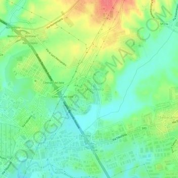
Name: Topografische Karte Casal Monastero, Höhe, Relief.
Ort: Casal Monastero, Rome, Roma Capitale, Lazio, 00131, Italy (41.92596 12.58107 41.96596 12.62107)
Durchschnittliche Höhe: 41 m
Minimale Höhe: 18 m
Maximale Höhe: 80 m
Andere topografische Karten
Klicken Sie auf eine Karte, um ihre Topografie, ihre Höhe und ihr Relief anzuzeigen.
Palatine Hill
Italy > Lazio > Roma Capitale > Rome
Palatine Hill, Campitelli, Municipio Roma I, Rome, Roma Capitale, Lazio, 00184, Italy
Durchschnittliche Höhe: 40 m
Infernetto
Italy > Lazio > Roma Capitale > Rome
Infernetto, Rome, Roma Capitale, Lazio, 00124, Italy
Durchschnittliche Höhe: 25 m
Fontana di piazza dell'Aracoeli
Italy > Lazio > Roma Capitale > Rome
Fontana di piazza dell'Aracoeli, Campitelli, Municipio Roma I, Rome, Roma Capitale, Lazio, Italy
Durchschnittliche Höhe: 39 m