
Topografische Karte Palatine Hill
Interaktive Karte
Klicken Sie auf die Karte, um die Höhe anzuzeigen.
Über diese Karte
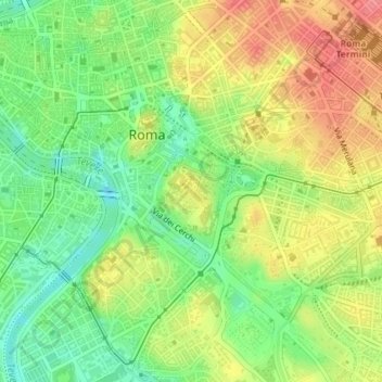
Name: Topografische Karte Palatine Hill, Höhe, Relief.
Durchschnittliche Höhe: 40 m
Minimale Höhe: 3 m
Maximale Höhe: 79 m
In 2007 the legendary Lupercal cave was claimed to have been found beneath the remains of the Domus Livia (House of Livia) on the Palatine. Archaeologists came across the 16-metre-deep cavity while restoring the decaying palace, with a richly decorated vault encrusted with mosaics and seashells. The Lupercal was probably converted to a sanctuary by Romans in later centuries. Many others have denied its identification with the Lupercal on topographic and stylistic grounds, and believe that the grotto is actually a nymphaeum or underground triclinium from Neronian times.
Andere topografische Karten
Klicken Sie auf eine Karte, um ihre Topografie, ihre Höhe und ihr Relief anzuzeigen.
Casal Monastero
Italy > Lazio > Roma Capitale > Rome
Casal Monastero, Rome, Roma Capitale, Lazio, 00131, Italy
Durchschnittliche Höhe: 41 m
Infernetto
Italy > Lazio > Roma Capitale > Rome
Infernetto, Rome, Roma Capitale, Lazio, 00124, Italy
Durchschnittliche Höhe: 25 m
Fontana di piazza dell'Aracoeli
Italy > Lazio > Roma Capitale > Rome
Fontana di piazza dell'Aracoeli, Campitelli, Municipio Roma I, Rome, Roma Capitale, Lazio, Italy
Durchschnittliche Höhe: 39 m