
Topografische Karte Vosges
Interaktive Karte
Klicken Sie auf die Karte, um die Höhe anzuzeigen.
Über diese Karte
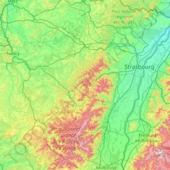
Name: Topografische Karte Vosges, Höhe, Relief.
Ort: Vosges, Grand Est, Metropolitan France, France (47.72939 6.45701 49.12702 7.91222)
Durchschnittliche Höhe: 354 m
Minimale Höhe: 110 m
Maximale Höhe: 1.471 m
In addition, the term "Central Vosges" is used to designate the various lines of summits, especially those above 1,000 m (3,300 ft) in elevation. The French department of Vosges is named after the range.
Andere topografische Karten
Klicken Sie auf eine Karte, um ihre Topografie, ihre Höhe und ihr Relief anzuzeigen.
Thannenkirch
France > Grand Est > Haut-Rhin
Thannenkirch, Colmar-Ribeauvillé, Haut-Rhin, Grand Est, Metropolitan France, 68590, France
Durchschnittliche Höhe: 580 m
Gorcy
France > Grand Est > Meurthe-et-Moselle
Gorcy, Val-de-Briey, Meurthe-et-Moselle, Grand Est, Metropolitan France, 54730, France
Durchschnittliche Höhe: 317 m
Thélod
France > Grand Est > Meurthe-et-Moselle
Thélod, Nancy, Meurthe-et-Moselle, Grand Est, Metropolitan France, 54330, France
Durchschnittliche Höhe: 310 m
Jolivet
France > Grand Est > Meurthe-et-Moselle
Jolivet, Lunéville, Meurthe-et-Moselle, Grand Est, Metropolitan France, 54300, France
Durchschnittliche Höhe: 249 m
Walschbronn
Walschbronn, Sarreguemines, Moselle, Grand Est, Metropolitan France, 57720, France
Durchschnittliche Höhe: 328 m
Crecy
France > Grand Est > Ardennes > Brieulles-sur-Bar
Crecy, Brieulles-sur-Bar, Vouziers, Ardennes, Grand Est, Metropolitan France, 08240, France
Durchschnittliche Höhe: 198 m
Tieffenbach
Tieffenbach, Saverne, Bas-Rhin, Grand Est, Metropolitan France, 67290, France
Durchschnittliche Höhe: 307 m
Harchéchamp
Harchéchamp, Neufchâteau, Vosges, Grand Est, Metropolitan France, 88300, France
Durchschnittliche Höhe: 348 m
Blevaincourt
Blevaincourt, Neufchâteau, Vosges, Grand Est, Metropolitan France, 88320, France
Durchschnittliche Höhe: 361 m
Andelot-Blancheville
France > Grand Est > Haute-Marne
Andelot-Blancheville, Chaumont, Haute-Marne, Grand Est, Metropolitan France, 52700, France
Durchschnittliche Höhe: 319 m
Pargny-sur-Saulx
Pargny-sur-Saulx, Vitry-le-François, Marne, Grand Est, Metropolitan France, 51340, France
Durchschnittliche Höhe: 130 m
Vallentigny
Vallentigny, Bar-sur-Aube, Aube, Grand Est, Metropolitan France, 10500, France
Durchschnittliche Höhe: 124 m
57230
France > Grand Est > Moselle > Éguelshardt
57230, Éguelshardt, Sarreguemines, Moselle, Grand Est, Metropolitan France, France
Durchschnittliche Höhe: 307 m
Moulins-Saint-Hubert
Moulins-Saint-Hubert, Verdun, Meuse, Grand Est, Metropolitan France, 55700, France
Durchschnittliche Höhe: 247 m
Pexonne
France > Grand Est > Meurthe-et-Moselle
Pexonne, Lunéville, Meurthe-et-Moselle, Grand Est, Metropolitan France, 54540, France
Durchschnittliche Höhe: 348 m
Bicqueley
France > Grand Est > Meurthe-et-Moselle
Bicqueley, Toul, Meurthe-et-Moselle, Grand Est, Metropolitan France, 54200, France
Durchschnittliche Höhe: 251 m
52150
France > Grand Est > Haute-Marne > Bourmont-entre-Meuse-et-Mouzon
52150, Bourmont, Bourmont-entre-Meuse-et-Mouzon, Chaumont, Haute-Marne, Grand Est, Metropolitan France, France
Durchschnittliche Höhe: 409 m
Rupt-aux-Nonains
Rupt-aux-Nonains, Bar-le-Duc, Meuse, Grand Est, Metropolitan France, 55170, France
Durchschnittliche Höhe: 238 m
Friesenheim
Friesenheim, Sélestat-Erstein, Bas-Rhin, Grand Est, Metropolitan France, 67860, France
Durchschnittliche Höhe: 160 m
Breitenbach
Breitenbach, Sélestat-Erstein, Bas-Rhin, Grand Est, Metropolitan France, 67220, France
Durchschnittliche Höhe: 608 m
Strasbourg
Strasbourg, Bas-Rhin, Grand Est, Metropolitan France, France
Durchschnittliche Höhe: 144 m
Mont-Saint-Martin
France > Grand Est > Meurthe-et-Moselle
Mont-Saint-Martin, Val-de-Briey, Meurthe-et-Moselle, Grand Est, Metropolitan France, 54350, France
Durchschnittliche Höhe: 309 m
Vic-sur-Seille
Vic-sur-Seille, Sarrebourg-Château-Salins, Moselle, Grand Est, Metropolitan France, 57630, France
Durchschnittliche Höhe: 240 m
Longor
France > Grand Est > Meuse > Pagny-sur-Meuse
Longor, Pagny-sur-Meuse, Commercy, Meuse, Grand Est, Metropolitan France, 55190, France
Durchschnittliche Höhe: 270 m
Fort de Jouy
France > Grand Est > Meuse > Geville > Jouy-sous-les-Côtes
Fort de Jouy, Rue du Fort, Jouy-sous-les-Côtes, Geville, Commercy, Meuse, Grand Est, Metropolitan France, 55200, France
Durchschnittliche Höhe: 312 m
Wanne
France > Grand Est > Haut-Rhin > Dietwiller
Wanne, Dietwiller, Mulhouse, Haut-Rhin, Grand Est, Metropolitan France, 68440, France
Durchschnittliche Höhe: 282 m
Mangiennes
Mangiennes, Verdun, Meuse, Grand Est, Metropolitan France, 55150, France
Durchschnittliche Höhe: 218 m
Ay
France > Grand Est > Marne > Aÿ-Champagne
Ay, Aÿ-Champagne, Épernay, Marne, Grand Est, Metropolitan France, France
Durchschnittliche Höhe: 131 m
Mont Saint-Quentin
France > Grand Est > Moselle > Scy-Chazelles
Mont Saint-Quentin, Scy-Chazelles, Metz, Moselle, Grand Est, Metropolitan France, 57160, France
Durchschnittliche Höhe: 237 m
Châlons-en-Champagne
Châlons-en-Champagne, Marne, Grand Est, Metropolitan France, 51000, France
Durchschnittliche Höhe: 99 m
Bourgogne
France > Grand Est > Marne > Bourgogne-Fresne
Bourgogne, Bourgogne-Fresne, Reims, Marne, Grand Est, Metropolitan France, 51110, France
Durchschnittliche Höhe: 88 m