
Topografische Karte Mont-Saint-Martin
Interaktive Karte
Klicken Sie auf die Karte, um die Höhe anzuzeigen.
Über diese Karte
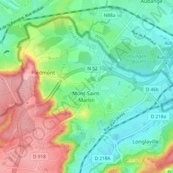
Name: Topografische Karte Mont-Saint-Martin, Höhe, Relief.
Durchschnittliche Höhe: 309 m
Minimale Höhe: 256 m
Maximale Höhe: 404 m
Andere topografische Karten
Klicken Sie auf eine Karte, um ihre Topografie, ihre Höhe und ihr Relief anzuzeigen.
Gorcy
France > Grand Est > Meurthe-et-Moselle
Gorcy, Val-de-Briey, Meurthe-et-Moselle, Grand Est, Metropolitan France, 54730, France
Durchschnittliche Höhe: 317 m
Thélod
France > Grand Est > Meurthe-et-Moselle
Thélod, Nancy, Meurthe-et-Moselle, Grand Est, Metropolitan France, 54330, France
Durchschnittliche Höhe: 310 m
Jolivet
France > Grand Est > Meurthe-et-Moselle
Jolivet, Lunéville, Meurthe-et-Moselle, Grand Est, Metropolitan France, 54300, France
Durchschnittliche Höhe: 249 m
Pexonne
France > Grand Est > Meurthe-et-Moselle
Pexonne, Lunéville, Meurthe-et-Moselle, Grand Est, Metropolitan France, 54540, France
Durchschnittliche Höhe: 348 m
Bicqueley
France > Grand Est > Meurthe-et-Moselle
Bicqueley, Toul, Meurthe-et-Moselle, Grand Est, Metropolitan France, 54200, France
Durchschnittliche Höhe: 251 m
Pont-à-Mousson
France > Grand Est > Meurthe-et-Moselle
Pont-à-Mousson, Nancy, Meurthe-et-Moselle, Grand Est, Metropolitan France, 54700, France
Durchschnittliche Höhe: 234 m
Mars-la-Tour
France > Grand Est > Meurthe-et-Moselle
Mars-la-Tour, Toul, Meurthe-et-Moselle, Grand Est, Metropolitan France, 54800, France
Durchschnittliche Höhe: 241 m
Chemin des Postes
France > Grand Est > Meurthe-et-Moselle > Tantonville
Chemin des Postes, Tantonville, Nancy, Meurthe-et-Moselle, Grand Est, Metropolitan France, 54116, France
Durchschnittliche Höhe: 288 m
Saint-Sauveur
France > Grand Est > Meurthe-et-Moselle > Saint-Sauveur
Saint-Sauveur, Lunéville, Meurthe-et-Moselle, Grand Est, Metropolitan France, 54480, France
Durchschnittliche Höhe: 417 m
Sarazin
France > Grand Est > Meurthe-et-Moselle > Vaucourt
Sarazin, Vaucourt, Lunéville, Meurthe-et-Moselle, Grand Est, Metropolitan France, 54370, France
Durchschnittliche Höhe: 260 m
Poire en Rupt
France > Grand Est > Meurthe-et-Moselle > Thorey-Lyautey
Poire en Rupt, Thorey-Lyautey, Nancy, Meurthe-et-Moselle, Grand Est, Metropolitan France, 54115, France
Durchschnittliche Höhe: 317 m
Landres
France > Grand Est > Meurthe-et-Moselle > Landres
Landres, Briey, Meurthe-et-Moselle, Grand Est, Metropolitan France, 54970, France
Durchschnittliche Höhe: 310 m
Mercy-le-Bas
France > Grand Est > Meurthe-et-Moselle > Mercy-le-Bas
Mercy-le-Bas, Briey, Meurthe-et-Moselle, Grand Est, Metropolitan France, 54960, France
Durchschnittliche Höhe: 289 m
Nancy
France > Grand Est > Meurthe-et-Moselle
Nancy, Meurthe-et-Moselle, Grand Est, Metropolitan France, France
Durchschnittliche Höhe: 230 m
Belleville
France > Grand Est > Meurthe-et-Moselle
Belleville, Nancy, Meurthe-et-Moselle, Grand Est, Metropolitan France, 54940, France
Durchschnittliche Höhe: 236 m
Serres
France > Grand Est > Meurthe-et-Moselle
Serres, Lunéville, Meurthe-et-Moselle, Grand Est, Metropolitan France, 54370, France
Durchschnittliche Höhe: 272 m
Bures
France > Grand Est > Meurthe-et-Moselle
Bures, Lunéville, Meurthe-et-Moselle, Grand Est, Metropolitan France, 54370, France
Durchschnittliche Höhe: 256 m
Moutiers
France > Grand Est > Meurthe-et-Moselle
Moutiers, Briey, Meurthe-et-Moselle, Grand Est, Metropolitan France, 54660, France
Durchschnittliche Höhe: 239 m
Germiny
France > Grand Est > Meurthe-et-Moselle
Germiny, Toul, Meurthe-et-Moselle, Grand Est, Metropolitan France, 54170, France
Durchschnittliche Höhe: 356 m