
Topografische Karte Wildcat Mountain
Interaktive Karte
Klicken Sie auf die Karte, um die Höhe anzuzeigen.
Über diese Karte
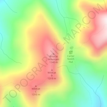
Name: Topografische Karte Wildcat Mountain, Höhe, Relief.
Ort: Wildcat Mountain, Coös County, New Hampshire, United States (44.25890 -71.20151 44.25900 -71.20141)
Durchschnittliche Höhe: 1.055 m
Minimale Höhe: 738 m
Maximale Höhe: 1.406 m
Wildcat Mountain has five summits — A, B, C, D, and E — along Wildcat Ridge, which curves two miles (3 km) to the south and west. Both A, at 4,422 feet (1,348 m), and D, at 4,062 feet (1,238 m), are considered "four-thousand footers". B, with an elevation of 4,305 feet (1,312 m), and C, at 4,285 feet (1,306 m), lack the topographic prominence to be considered more than subpeaks of Wildcat A. Likewise, the E peak, at 4,046 feet (1,233 m), is considered to be a subpeak of the higher D peak (the E peak was formerly believed to be the higher of the two, and used to appear on the official list of four-thousand footers, but current topographic maps reveal the D peak to be the higher summit).
Andere topografische Karten
Klicken Sie auf eine Karte, um ihre Topografie, ihre Höhe und ihr Relief anzuzeigen.
Kidderville
United States > New Hampshire > Coos County > Colebrook
Kidderville, Colebrook, Coös County, New Hampshire, United States
Durchschnittliche Höhe: 472 m
Dixville
United States > New Hampshire > Coos County
Dixville, Coös County, New Hampshire, United States
Durchschnittliche Höhe: 635 m
Mount Washington
United States > New Hampshire > Coos County
Mount Washington, Coös County, New Hampshire, United States
Durchschnittliche Höhe: 1.568 m
Northumberland
United States > New Hampshire > Coos County
Northumberland, Coös County, New Hampshire, United States
Durchschnittliche Höhe: 383 m
Stark
United States > New Hampshire > Coos County
Stark, Coös County, New Hampshire, United States
Durchschnittliche Höhe: 526 m
Shelburne
United States > New Hampshire > Coos County
Shelburne, Coös County, New Hampshire, United States
Durchschnittliche Höhe: 467 m
Groveton
United States > New Hampshire > Coos County
Groveton, Northumberland, Coös County, New Hampshire, United States
Durchschnittliche Höhe: 304 m
Columbia
United States > New Hampshire > Coos County
Columbia, Coös County, New Hampshire, United States
Durchschnittliche Höhe: 553 m
Dummer
United States > New Hampshire > Coos County
Dummer, Coös County, New Hampshire, United States
Durchschnittliche Höhe: 419 m
Twin Mountain
United States > New Hampshire > Coos County > Carroll
Twin Mountain, Carroll, Coös County, New Hampshire, 03595, United States
Durchschnittliche Höhe: 490 m
Pinkham Notch
United States > New Hampshire > Coos County
Pinkham Notch, Pinkham's Grant, Coös County, New Hampshire, United States
Durchschnittliche Höhe: 767 m
Milan
United States > New Hampshire > Coos County
Milan, Coös County, New Hampshire, 03588, United States
Durchschnittliche Höhe: 448 m
Stratford
United States > New Hampshire > Coos County
Stratford, Coös County, New Hampshire, 03590, United States
Durchschnittliche Höhe: 497 m
Castellated Ridge
United States > New Hampshire > Coos County
Castellated Ridge, Low and Burbank's Grant, Coös County, New Hampshire, United States
Durchschnittliche Höhe: 1.080 m
Lost Nation
United States > New Hampshire > Coos County > Northumberland
Lost Nation, Northumberland, Coös County, New Hampshire, United States
Durchschnittliche Höhe: 363 m
North Stratford
United States > New Hampshire > Coos County
North Stratford, Stratford, Coös County, New Hampshire, 03590, United States
Durchschnittliche Höhe: 340 m
Colebrook
United States > New Hampshire > Coos County
Colebrook, Coös County, New Hampshire, 03576, United States
Durchschnittliche Höhe: 476 m
Whitefield
United States > New Hampshire > Coos County
Whitefield, Coös County, New Hampshire, United States
Durchschnittliche Höhe: 365 m
Gorham
United States > New Hampshire > Coos County
Gorham, Coös County, New Hampshire, 03581, United States
Durchschnittliche Höhe: 477 m
Upper Kidderville
United States > New Hampshire > Coos County > Colebrook
Upper Kidderville, Colebrook, Coos County, New Hampshire, United States
Durchschnittliche Höhe: 478 m
Pittsburg
United States > New Hampshire > Coos County
Pittsburg, Coös County, New Hampshire, United States
Durchschnittliche Höhe: 522 m
Castle Mountain
United States > New Hampshire > Coos County
Castle Mountain, Coos County, New Hampshire, United States
Durchschnittliche Höhe: 937 m
Carroll
United States > New Hampshire > Coos County
Carroll, Coös County, New Hampshire, United States
Durchschnittliche Höhe: 562 m
Lancaster
United States > New Hampshire > Coos County
Lancaster, Coös County, New Hampshire, 03584, United States
Durchschnittliche Höhe: 371 m
Bretton Woods
United States > New Hampshire > Coos County > Carroll
Bretton Woods, Carroll, Coös County, New Hampshire, 03575, United States
Durchschnittliche Höhe: 577 m
Clarksville
United States > New Hampshire > Coos County
Clarksville, Coös County, New Hampshire, United States
Durchschnittliche Höhe: 570 m
Mount Crescent
United States > New Hampshire > Coos County
Mount Crescent, Coos County, New Hampshire, 03593, United States
Durchschnittliche Höhe: 748 m
Triple Falls
United States > New Hampshire > Coos County > Gorham
Triple Falls, Gorham, Coos County, New Hampshire, 03593, United States
Durchschnittliche Höhe: 558 m
Randolph
United States > New Hampshire > Coos County
Randolph, Coös County, New Hampshire, 03593, United States
Durchschnittliche Höhe: 594 m
LIttle Diamond Pond
United States > New Hampshire > Coos County > Stewartstown
LIttle Diamond Pond, Stewartstown, Coos County, New Hampshire, United States
Durchschnittliche Höhe: 693 m
Jefferson Highland
United States > New Hampshire > Coos County > Jefferson > Jefferson Highland
Jefferson Highland, Jefferson, Coos County, New Hampshire, 03583, United States
Durchschnittliche Höhe: 451 m
Jefferson
United States > New Hampshire > Coos County
Jefferson, Coös County, New Hampshire, 03583, United States
Durchschnittliche Höhe: 493 m
Dixville Notch
United States > New Hampshire > Coos County
Dixville Notch, Coos County, New Hampshire, United States
Durchschnittliche Höhe: 655 m
Stewartstown
United States > New Hampshire > Coos County
Stewartstown, Coös County, New Hampshire, 03597, United States
Durchschnittliche Höhe: 485 m
Dalton
United States > New Hampshire > Coos County
Dalton, Coös County, New Hampshire, United States
Durchschnittliche Höhe: 375 m
Errol
United States > New Hampshire > Coos County
Errol, Coös County, New Hampshire, United States
Durchschnittliche Höhe: 453 m
Mount Eisenhower
United States > New Hampshire > Coos County
Mount Eisenhower, Coos County, New Hampshire, 03589, United States
Durchschnittliche Höhe: 1.142 m