
Topografische Karte Lancaster
Interaktive Karte
Klicken Sie auf die Karte, um die Höhe anzuzeigen.
Über diese Karte
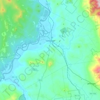
Name: Topografische Karte Lancaster, Höhe, Relief.
Ort: Lancaster, Coös County, New Hampshire, 03584, United States (44.41019 -71.66063 44.53864 -71.42977)
Durchschnittliche Höhe: 371 m
Minimale Höhe: 247 m
Maximale Höhe: 1.105 m
Just south of the village center is Mount Prospect, summer home to Senator John W. Weeks, who sponsored congressional legislation creating White Mountain National Forest. In 1910, he purchased several farms to assemble the 420-acre (170 ha) estate. It is now Weeks State Park, which features a fire lookout and his mansion, open for tours during the summer. The Mount Prospect Ski Tow operates on the slope in winter, snow conditions permitting. Many of the White Mountains and Green Mountains can be seen from the stone observation tower built in 1912 atop the 2,059-foot (628 m) summit. The Presidential Range is to the southeast, with the Franconia Range to the south. Mount Weeks, elevation 3,900 ft (1,200 m), is in the Kilkenny Range to the northeast. It is named for the senator, as is the Weeks Medical Center. Weeks Memorial Library, a Beaux Arts landmark listed on the National Register of Historic Places in 2000, was given by John W. Weeks in memory of his father, William Dennis Weeks.
Andere topografische Karten
Klicken Sie auf eine Karte, um ihre Topografie, ihre Höhe und ihr Relief anzuzeigen.
Kidderville
United States > New Hampshire > Coos County > Colebrook
Kidderville, Colebrook, Coös County, New Hampshire, United States
Durchschnittliche Höhe: 472 m
Dixville
United States > New Hampshire > Coos County
Dixville, Coös County, New Hampshire, United States
Durchschnittliche Höhe: 635 m
Mount Washington
United States > New Hampshire > Coos County
Mount Washington, Coös County, New Hampshire, United States
Durchschnittliche Höhe: 1.568 m
Northumberland
United States > New Hampshire > Coos County
Northumberland, Coös County, New Hampshire, United States
Durchschnittliche Höhe: 383 m
Stark
United States > New Hampshire > Coos County
Stark, Coös County, New Hampshire, United States
Durchschnittliche Höhe: 526 m
Shelburne
United States > New Hampshire > Coos County
Shelburne, Coös County, New Hampshire, United States
Durchschnittliche Höhe: 467 m
Groveton
United States > New Hampshire > Coos County
Groveton, Northumberland, Coös County, New Hampshire, United States
Durchschnittliche Höhe: 304 m
Columbia
United States > New Hampshire > Coos County
Columbia, Coös County, New Hampshire, United States
Durchschnittliche Höhe: 553 m
Dummer
United States > New Hampshire > Coos County
Dummer, Coös County, New Hampshire, United States
Durchschnittliche Höhe: 419 m
Twin Mountain
United States > New Hampshire > Coos County > Carroll
Twin Mountain, Carroll, Coös County, New Hampshire, 03595, United States
Durchschnittliche Höhe: 490 m
Pinkham Notch
United States > New Hampshire > Coos County
Pinkham Notch, Pinkham's Grant, Coös County, New Hampshire, United States
Durchschnittliche Höhe: 767 m
Milan
United States > New Hampshire > Coos County
Milan, Coös County, New Hampshire, 03588, United States
Durchschnittliche Höhe: 448 m
Stratford
United States > New Hampshire > Coos County
Stratford, Coös County, New Hampshire, 03590, United States
Durchschnittliche Höhe: 497 m
Castellated Ridge
United States > New Hampshire > Coos County
Castellated Ridge, Low and Burbank's Grant, Coös County, New Hampshire, United States
Durchschnittliche Höhe: 1.080 m
Lost Nation
United States > New Hampshire > Coos County > Northumberland
Lost Nation, Northumberland, Coös County, New Hampshire, United States
Durchschnittliche Höhe: 363 m
North Stratford
United States > New Hampshire > Coos County
North Stratford, Stratford, Coös County, New Hampshire, 03590, United States
Durchschnittliche Höhe: 340 m
Colebrook
United States > New Hampshire > Coos County
Colebrook, Coös County, New Hampshire, 03576, United States
Durchschnittliche Höhe: 476 m
Whitefield
United States > New Hampshire > Coos County
Whitefield, Coös County, New Hampshire, United States
Durchschnittliche Höhe: 365 m
Gorham
United States > New Hampshire > Coos County
Gorham, Coös County, New Hampshire, 03581, United States
Durchschnittliche Höhe: 477 m
Wildcat Mountain
United States > New Hampshire > Coos County
Wildcat Mountain, Coös County, New Hampshire, United States
Durchschnittliche Höhe: 1.055 m
Upper Kidderville
United States > New Hampshire > Coos County > Colebrook
Upper Kidderville, Colebrook, Coos County, New Hampshire, United States
Durchschnittliche Höhe: 478 m
Pittsburg
United States > New Hampshire > Coos County
Pittsburg, Coös County, New Hampshire, United States
Durchschnittliche Höhe: 522 m
Castle Mountain
United States > New Hampshire > Coos County
Castle Mountain, Coos County, New Hampshire, United States
Durchschnittliche Höhe: 937 m
Carroll
United States > New Hampshire > Coos County
Carroll, Coös County, New Hampshire, United States
Durchschnittliche Höhe: 562 m
Bretton Woods
United States > New Hampshire > Coos County > Carroll
Bretton Woods, Carroll, Coös County, New Hampshire, 03575, United States
Durchschnittliche Höhe: 577 m
Clarksville
United States > New Hampshire > Coos County
Clarksville, Coös County, New Hampshire, United States
Durchschnittliche Höhe: 570 m
Mount Crescent
United States > New Hampshire > Coos County
Mount Crescent, Coos County, New Hampshire, 03593, United States
Durchschnittliche Höhe: 748 m
Triple Falls
United States > New Hampshire > Coos County > Gorham
Triple Falls, Gorham, Coos County, New Hampshire, 03593, United States
Durchschnittliche Höhe: 558 m
Randolph
United States > New Hampshire > Coos County
Randolph, Coös County, New Hampshire, 03593, United States
Durchschnittliche Höhe: 594 m
LIttle Diamond Pond
United States > New Hampshire > Coos County > Stewartstown
LIttle Diamond Pond, Stewartstown, Coos County, New Hampshire, United States
Durchschnittliche Höhe: 693 m
Jefferson Highland
United States > New Hampshire > Coos County > Jefferson > Jefferson Highland
Jefferson Highland, Jefferson, Coos County, New Hampshire, 03583, United States
Durchschnittliche Höhe: 451 m
Jefferson
United States > New Hampshire > Coos County
Jefferson, Coös County, New Hampshire, 03583, United States
Durchschnittliche Höhe: 493 m
Dixville Notch
United States > New Hampshire > Coos County
Dixville Notch, Coos County, New Hampshire, United States
Durchschnittliche Höhe: 655 m
Stewartstown
United States > New Hampshire > Coos County
Stewartstown, Coös County, New Hampshire, 03597, United States
Durchschnittliche Höhe: 485 m
Dalton
United States > New Hampshire > Coos County
Dalton, Coös County, New Hampshire, United States
Durchschnittliche Höhe: 375 m
Errol
United States > New Hampshire > Coos County
Errol, Coös County, New Hampshire, United States
Durchschnittliche Höhe: 453 m
Mount Eisenhower
United States > New Hampshire > Coos County
Mount Eisenhower, Coos County, New Hampshire, 03589, United States
Durchschnittliche Höhe: 1.142 m