
Spenden
Rüsten Sie sich für Ihr nächstes Abenteuer:
Als Amazon-Partner erhält diese Website eine Provision für qualifizierte Käufe, ohne zusätzliche Kosten für Sie.
Topografische Karte Georgina Island
Klicken Sie auf die Karte, um die Höhe anzuzeigen.
Spenden
Rüsten Sie sich für Ihr nächstes Abenteuer:
Als Amazon-Partner erhält diese Website eine Provision für qualifizierte Käufe, ohne zusätzliche Kosten für Sie.
Über diese Karte
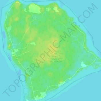
Name: Topografische Karte Georgina Island, Höhe, Relief.
Durchschnittliche Höhe: 221 m
Minimale Höhe: 215 m
Maximale Höhe: 233 m
Spenden
Rüsten Sie sich für Ihr nächstes Abenteuer:
Als Amazon-Partner erhält diese Website eine Provision für qualifizierte Käufe, ohne zusätzliche Kosten für Sie.
Andere topografische Karten
Klicken Sie auf eine Karte, um ihre Topografie, ihre Höhe und ihr Relief anzuzeigen.
Richmond Hill
Canada > Ontario > York Region
The village of Richmond Hill was incorporated by a bylaw of the York County Council on June 18, 1872, coming into effect January 1, 1873. In September 1956, the Ontario Municipal Board approved its elevation to Town status, effective January 1, 1957.
Durchschnittliche Höhe: 256 m
Spenden
Rüsten Sie sich für Ihr nächstes Abenteuer:
Als Amazon-Partner erhält diese Website eine Provision für qualifizierte Käufe, ohne zusätzliche Kosten für Sie.
Markham
Canada > Ontario > York Region
Markham's average altitude is at 200 m (660 ft) and in general consists of gently rolling hills. The city is intersected by two rivers; the Don River and Rouge River, as well as their tributaries. To the north is the Oak Ridges Moraine, which further elevates the elevation towards the north.
Durchschnittliche Höhe: 216 m
Newmarket
Canada > Ontario > York Region
Newmarket's geographical coordinates are 44.05°N, 79.46°W, and its elevation above sea level is 252 m. It has an area of 38.33 km². The town is bounded on the south by Aurora, on the west by King, on the north by East Gwillimbury and on the east by Whitchurch–Stouffville.
Durchschnittliche Höhe: 270 m
Spenden
Rüsten Sie sich für Ihr nächstes Abenteuer:
Als Amazon-Partner erhält diese Website eine Provision für qualifizierte Käufe, ohne zusätzliche Kosten für Sie.
Keswick
Canada > Ontario > York Region
Keswick's geographical coordinates are 44.22°N, 79.45°W, and its elevation above sea level is 221m/762 ft. It has a geographical area of 16.25 km² according to Statistics Canada. It is bound on the north by Roches Point, the east by Woodbine Avenue, the south by East Gwillimbury (Ravenshoe Road) and the…
Durchschnittliche Höhe: 228 m
Spenden
Rüsten Sie sich für Ihr nächstes Abenteuer:
Als Amazon-Partner erhält diese Website eine Provision für qualifizierte Käufe, ohne zusätzliche Kosten für Sie.
Spenden
Rüsten Sie sich für Ihr nächstes Abenteuer:
Als Amazon-Partner erhält diese Website eine Provision für qualifizierte Käufe, ohne zusätzliche Kosten für Sie.
Spenden
Rüsten Sie sich für Ihr nächstes Abenteuer:
Als Amazon-Partner erhält diese Website eine Provision für qualifizierte Käufe, ohne zusätzliche Kosten für Sie.
Spenden
Rüsten Sie sich für Ihr nächstes Abenteuer:
Als Amazon-Partner erhält diese Website eine Provision für qualifizierte Käufe, ohne zusätzliche Kosten für Sie.
Newmarket
Canada > Ontario > York Region
Newmarket's geographical coordinates are 44.05°N, 79.46°W, and its elevation above sea level is 252 m. It has an area of 38.33 km2. The town is bounded on the south by Aurora, on the west by King, on the north by East Gwillimbury and on the east by Whitchurch–Stouffville.
Durchschnittliche Höhe: 270 m
Spenden
Rüsten Sie sich für Ihr nächstes Abenteuer:
Als Amazon-Partner erhält diese Website eine Provision für qualifizierte Käufe, ohne zusätzliche Kosten für Sie.
Markham
Canada > Ontario > York Region
Markham's average altitude is at 200 m (660 ft) and in general consists of gently rolling hills. The city is intersected by two rivers; the Don River and Rouge River, as well as their tributaries. To the north is the Oak Ridges Moraine, which further elevates the elevation towards the north.
Durchschnittliche Höhe: 216 m
Richmond Hill
Canada > Ontario > York Region
The village of Richmond Hill was incorporated by a by-law of the York County Council on June 18, 1872, coming into effect January 1, 1873. In September 1956, the Ontario Municipal Board approved its elevation to Town status, effective January 1, 1957.
Durchschnittliche Höhe: 256 m
Spenden
Rüsten Sie sich für Ihr nächstes Abenteuer:
Als Amazon-Partner erhält diese Website eine Provision für qualifizierte Käufe, ohne zusätzliche Kosten für Sie.
Richmond Hill
Canada > Ontario > York Region
The village of Richmond Hill was incorporated by a bylaw of the York County Council on June 18, 1872, coming into effect January 1, 1873. In September 1956, the Ontario Municipal Board approved its elevation to Town status, effective January 1, 1957.
Durchschnittliche Höhe: 256 m
Spenden
Rüsten Sie sich für Ihr nächstes Abenteuer:
Als Amazon-Partner erhält diese Website eine Provision für qualifizierte Käufe, ohne zusätzliche Kosten für Sie.
Markham
Canada > Ontario > York Region
Markham's average altitude is at 200 m (660 ft) and in general consists of gently rolling hills. The city is intersected by two rivers; the Don River and Rouge River, as well as their tributaries. To the north is the Oak Ridges Moraine, which further elevates the elevation towards the north.
Durchschnittliche Höhe: 216 m
Spenden
Rüsten Sie sich für Ihr nächstes Abenteuer:
Als Amazon-Partner erhält diese Website eine Provision für qualifizierte Käufe, ohne zusätzliche Kosten für Sie.
Markham
Canada > Ontario > York Region
Markham's average altitude is at 200 m (660 ft) and in general consists of gently rolling hills. The city is intersected by two rivers; the Don River and Rouge River, as well as their tributaries. To the north is the Oak Ridges Moraine, which further elevates the elevation towards the north.
Durchschnittliche Höhe: 216 m
Richmond Hill
Canada > Ontario > York Region
The village of Richmond Hill was incorporated by a bylaw of the York County Council on June 18, 1872, coming into effect January 1, 1873. In September 1956, the Ontario Municipal Board approved its elevation to Town status, effective January 1, 1957.
Durchschnittliche Höhe: 256 m
Spenden
Rüsten Sie sich für Ihr nächstes Abenteuer:
Als Amazon-Partner erhält diese Website eine Provision für qualifizierte Käufe, ohne zusätzliche Kosten für Sie.
Richmond Hill
Canada > Ontario > York Region
The village of Richmond Hill was incorporated by a bylaw of the York County Council on June 18, 1872, coming into effect January 1, 1873. In September 1956, the Ontario Municipal Board approved its elevation to Town status, effective January 1, 1957.
Durchschnittliche Höhe: 256 m
Markham
Canada > Ontario > York Region
Markham's average altitude is at 200 m (660 ft) and in general consists of gently rolling hills. The city is intersected by two rivers; the Don River and Rouge River, as well as their tributaries. To the north is the Oak Ridges Moraine, which further elevates the elevation towards the north.
Durchschnittliche Höhe: 216 m
Spenden
Rüsten Sie sich für Ihr nächstes Abenteuer:
Als Amazon-Partner erhält diese Website eine Provision für qualifizierte Käufe, ohne zusätzliche Kosten für Sie.
Spenden
Rüsten Sie sich für Ihr nächstes Abenteuer:
Als Amazon-Partner erhält diese Website eine Provision für qualifizierte Käufe, ohne zusätzliche Kosten für Sie.
Richmond Hill
Canada > Ontario > York Region
The village of Richmond Hill was incorporated by a bylaw of the York County Council on June 18, 1872, coming into effect January 1, 1873. In September 1956, the Ontario Municipal Board approved its elevation to Town status, effective January 1, 1957.
Durchschnittliche Höhe: 256 m
Spenden
Rüsten Sie sich für Ihr nächstes Abenteuer:
Als Amazon-Partner erhält diese Website eine Provision für qualifizierte Käufe, ohne zusätzliche Kosten für Sie.
Spenden
Rüsten Sie sich für Ihr nächstes Abenteuer:
Als Amazon-Partner erhält diese Website eine Provision für qualifizierte Käufe, ohne zusätzliche Kosten für Sie.
Rouge National Urban Park, Woodland Area
Canada > Ontario > York Region > Markham
Durchschnittliche Höhe: 174 m
Spenden
Rüsten Sie sich für Ihr nächstes Abenteuer:
Als Amazon-Partner erhält diese Website eine Provision für qualifizierte Käufe, ohne zusätzliche Kosten für Sie.
Keswick
Canada > Ontario > York Region
Keswick's geographical coordinates are 44.22°N, 79.45°W, and its elevation above sea level is 221m/762 ft. It has a geographical area of 16.25 km² according to Statistics Canada. It is bound on the north by Roches Point, the east by Woodbine Avenue, the south by East Gwillimbury (Ravenshoe Road) and the…
Durchschnittliche Höhe: 228 m