Geolokalisieren
👉 Easily get elevation data in JSON, GeoTIFF and KML formats using Elevation API
Vielen Dank für die Unterstützung dieser Website ❤️
Spenden

Topografische Karte Newmarket

Klicken Sie auf die Karte, um die Höhe anzuzeigen.

Newmarket

Newmarket's geographical coordinates are 44.05°N, 79.46°W, and its elevation above sea level is 252 m. It has an area of 38.33 km². The town is bounded on the south by Aurora, on the west by King, on the north by East Gwillimbury and on the east by Whitchurch–Stouffville.

Wikipedia (CC-BY-SA 3.0)

Über diese Karte

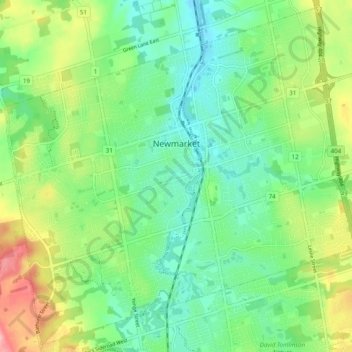
Name: Topografische Karte Newmarket, Höhe, Relief.

Ort: Newmarket, York Region, Golden Horseshoe, Ontario, Canada (44.01606 -79.50937 44.08345 -79.41174)

Durchschnittliche Höhe: 270 m

Minimale Höhe: 230 m

Maximale Höhe: 349 m

Andere topografische Karten

Klicken Sie auf eine Karte, um ihre Topografie, ihre Höhe und ihr Relief anzuzeigen.

Kleinburg

Canada > Ontario > York Region > Vaughan

Durchschnittliche Höhe: 206 m

North Maple Regional Park

Canada > Ontario > York Region > Vaughan

Durchschnittliche Höhe: 274 m

King City

Canada > Ontario > York Region > King

Durchschnittliche Höhe: 302 m

Keswick

Canada > Ontario > York Region

Keswick's geographical coordinates are 44.22°N, 79.45°W, and its elevation above sea level is 221m/762 ft. It has a geographical area of 16.25 km² according to Statistics Canada. It is bound on the north by Roches Point, the east by Woodbine Avenue, the south by East Gwillimbury (Ravenshoe Road) and the…

Durchschnittliche Höhe: 228 m

Georgina

Canada > Ontario > York Region

Durchschnittliche Höhe: 244 m

Schomberg

Canada > Ontario > York Region > King

Durchschnittliche Höhe: 243 m

Mill Pond

Canada > Ontario > York Region > Richmond Hill

Durchschnittliche Höhe: 240 m

Nobleton

Canada > Ontario > York Region > King

Durchschnittliche Höhe: 264 m

Sutton

Canada > Ontario > York Region

Durchschnittliche Höhe: 229 m

Holland River

Canada > Ontario > York Region > Bradford West Gwillimbury

Durchschnittliche Höhe: 220 m

Linton

Canada > Ontario > York Region > King

Durchschnittliche Höhe: 303 m

Cold Creek Conservation Area

Canada > Ontario > York Region > King

Durchschnittliche Höhe: 262 m

Vielen Dank für die Unterstützung dieser Website ❤️
Spenden

Rüsten Sie sich für Ihr nächstes Abenteuer:

Als Amazon-Partner erhält diese Website eine Provision für qualifizierte Käufe, ohne zusätzliche Kosten für Sie.

Whitchurch-Stouffville

Canada > Ontario > York Region

Durchschnittliche Höhe: 250 m

Strange

Canada > Ontario > York Region > King

Durchschnittliche Höhe: 289 m

Udora

Canada > Ontario > York Region > Georgina

Durchschnittliche Höhe: 244 m

Highland Gate Park

Canada > Ontario > York Region > Aurora

Durchschnittliche Höhe: 289 m

Vielen Dank für die Unterstützung dieser Website ❤️
Spenden

Mount Albert

Canada > Ontario > York Region

Durchschnittliche Höhe: 261 m

Kettle Lake Park

Canada > Ontario > York Region > King > King City

Durchschnittliche Höhe: 294 m

Milne Dam Conservation Park

Canada > Ontario > York Region > Markham

Durchschnittliche Höhe: 181 m

Baldwin

Canada > Ontario > York Region > Georgina

Durchschnittliche Höhe: 231 m

McGregor Farm Park

Canada > Ontario > York Region > Newmarket

Durchschnittliche Höhe: 283 m

King City

Canada > Ontario > York Region > King

Durchschnittliche Höhe: 302 m

Sharon

Canada > Ontario > York Region > East Gwillimbury

Durchschnittliche Höhe: 268 m

Egypt

Canada > Ontario > York Region > Georgina

Durchschnittliche Höhe: 237 m

Brown Hill

Canada > Ontario > York Region > East Gwillimbury

Durchschnittliche Höhe: 233 m

Brown Hill Tract

Canada > Ontario > York Region > East Gwillimbury

Durchschnittliche Höhe: 239 m

Fairy Lake

Canada > Ontario > York Region > Newmarket

Durchschnittliche Höhe: 252 m

Bloomington

Canada > Ontario > York Region > Whitchurch-Stouffville

Durchschnittliche Höhe: 323 m

Georgina Island

Canada > Ontario > York Region

Durchschnittliche Höhe: 221 m

Pefferlaw

Canada > Ontario > York Region > Georgina

Durchschnittliche Höhe: 231 m

Ballantrae

Canada > Ontario > York Region > Whitchurch-Stouffville

Durchschnittliche Höhe: 335 m

Kettleby

Canada > Ontario > York Region > King

Durchschnittliche Höhe: 288 m

Phyllis Rawlinson Park

Canada > Ontario > York Region > Richmond Hill > Gormley

Durchschnittliche Höhe: 252 m

Blue Willow Square

Canada > Ontario > York Region > Vaughan

Durchschnittliche Höhe: 195 m

Kingsview Park

Canada > Ontario > York Region > Vaughan

Durchschnittliche Höhe: 222 m

Gilmore Park

Canada > Ontario > York Region > Vaughan

Durchschnittliche Höhe: 193 m

Cornell Rouge Woods

Canada > Ontario > York Region > Markham

Durchschnittliche Höhe: 204 m

Ansnorveldt

Canada > Ontario > York Region > King

Durchschnittliche Höhe: 229 m

Fairtree Pond

Canada > Ontario > York Region > Markham

Durchschnittliche Höhe: 173 m

Sibbald Point Provincial Park

Canada > Ontario > York Region > Sutton

Durchschnittliche Höhe: 225 m

Hawstone Park

Canada > Ontario > York Region > Vaughan

Durchschnittliche Höhe: 226 m

Gorham St Open Space

Canada > Ontario > York Region > Newmarket

Durchschnittliche Höhe: 252 m

Glenville

Canada > Ontario > York Region > King

Durchschnittliche Höhe: 279 m

Bell's Lake

Canada > Ontario > York Region > King

Durchschnittliche Höhe: 295 m

Keswick

Canada > Ontario > York Region

Keswick's geographical coordinates are 44.22°N, 79.45°W, and its elevation above sea level is 221m/762 ft. It has a geographical area of 16.25 km² according to Statistics Canada. It is bound on the north by Roches Point, the east by Woodbine Avenue, the south by East Gwillimbury (Ravenshoe Road) and the…

Durchschnittliche Höhe: 228 m

Vielen Dank für die Unterstützung dieser Website ❤️
Spenden

Rüsten Sie sich für Ihr nächstes Abenteuer:

🎒Trekkingrucksack 70L - Großer Rucksack für Mehrtagestouren mit Kartenfach
🔭Kinder-Ferngläser - Robuste Optik für kleine Entdecker
🥾Bergsteiger Ausrüstung Set - Komplettes Set für Bergexpeditionen
👟Zustiegsschuhe (Approach) - Griffige Schuhe für leichte Klettereien und Felszustiege
Notfall-Biwaksäcke - Überlebensausrüstung für unvorhergesehene Nächte im Freien

Als Amazon-Partner erhält diese Website eine Provision für qualifizierte Käufe, ohne zusätzliche Kosten für Sie.