
Spenden
Rüsten Sie sich für Ihr nächstes Abenteuer:
Als Amazon-Partner erhält diese Website eine Provision für qualifizierte Käufe, ohne zusätzliche Kosten für Sie.
Topografische Karte Interlachen
Klicken Sie auf die Karte, um die Höhe anzuzeigen.
Spenden
Rüsten Sie sich für Ihr nächstes Abenteuer:
Als Amazon-Partner erhält diese Website eine Provision für qualifizierte Käufe, ohne zusätzliche Kosten für Sie.
Über diese Karte
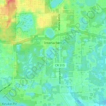
Name: Topografische Karte Interlachen, Höhe, Relief.
Ort: Interlachen, Putnam County, Florida, United States (29.59861 -81.93071 29.63881 -81.86996)
Durchschnittliche Höhe: 31 m
Minimale Höhe: 16 m
Maximale Höhe: 67 m
Spenden
Rüsten Sie sich für Ihr nächstes Abenteuer:
Als Amazon-Partner erhält diese Website eine Provision für qualifizierte Käufe, ohne zusätzliche Kosten für Sie.
Andere topografische Karten
Klicken Sie auf eine Karte, um ihre Topografie, ihre Höhe und ihr Relief anzuzeigen.
Georgetown
United States > Florida > Putnam County
Georgetown is located at 29°23′29″N 81°38′19″W / 29.391362°N 81.638689°W / 29.391362; -81.638689 (29.391362, -81.638689). Its elevation in 23 feet (7 m).
Durchschnittliche Höhe: 6 m
Spenden
Rüsten Sie sich für Ihr nächstes Abenteuer:
Als Amazon-Partner erhält diese Website eine Provision für qualifizierte Käufe, ohne zusätzliche Kosten für Sie.
Spenden
Rüsten Sie sich für Ihr nächstes Abenteuer:
Als Amazon-Partner erhält diese Website eine Provision für qualifizierte Käufe, ohne zusätzliche Kosten für Sie.
San Mateo
United States > Florida > Putnam County
San Mateo is located at 29°36′25″N 81°35′06″W / 29.607°N 81.585°W / 29.607; -81.585, with an elevation of 72 feet (22 m).
Durchschnittliche Höhe: 10 m
Spenden
Rüsten Sie sich für Ihr nächstes Abenteuer:
Als Amazon-Partner erhält diese Website eine Provision für qualifizierte Käufe, ohne zusätzliche Kosten für Sie.
Georgetown
United States > Florida > Putnam County
Georgetown is located at 29°23′29″N 81°38′19″W / 29.391362°N 81.638689°W / 29.391362; -81.638689 (29.391362, -81.638689). Its elevation in 23 feet (7 m).
Durchschnittliche Höhe: 6 m
Spenden
Rüsten Sie sich für Ihr nächstes Abenteuer:
Als Amazon-Partner erhält diese Website eine Provision für qualifizierte Käufe, ohne zusätzliche Kosten für Sie.