
Spenden
Rüsten Sie sich für Ihr nächstes Abenteuer:
Als Amazon-Partner erhält diese Website eine Provision für qualifizierte Käufe, ohne zusätzliche Kosten für Sie.
Topografische Karte Melrose
Klicken Sie auf die Karte, um die Höhe anzuzeigen.
Spenden
Rüsten Sie sich für Ihr nächstes Abenteuer:
Als Amazon-Partner erhält diese Website eine Provision für qualifizierte Käufe, ohne zusätzliche Kosten für Sie.
Über diese Karte
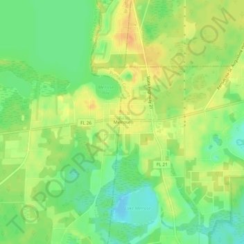
Name: Topografische Karte Melrose, Höhe, Relief.
Ort: Melrose, Putnam County, Florida, 32666, United States (29.68941 -82.06982 29.72941 -82.02982)
Durchschnittliche Höhe: 45 m
Minimale Höhe: 26 m
Maximale Höhe: 62 m
Spenden
Rüsten Sie sich für Ihr nächstes Abenteuer:
Als Amazon-Partner erhält diese Website eine Provision für qualifizierte Käufe, ohne zusätzliche Kosten für Sie.
Andere topografische Karten
Klicken Sie auf eine Karte, um ihre Topografie, ihre Höhe und ihr Relief anzuzeigen.
Palatka
United States > Florida > Putnam County
Palatka is located at 29°38′N 81°39′W / 29.633°N 81.650°W / 29.633; -81.650. The total area is 7.5 square miles (19 km2) and has an average elevation of 16 feet (4.8 m) above sea level. The city is located in the southern portion of the Lower St. Johns River basin.
Durchschnittliche Höhe: 8 m
Spenden
Rüsten Sie sich für Ihr nächstes Abenteuer:
Als Amazon-Partner erhält diese Website eine Provision für qualifizierte Käufe, ohne zusätzliche Kosten für Sie.
Spenden
Rüsten Sie sich für Ihr nächstes Abenteuer:
Als Amazon-Partner erhält diese Website eine Provision für qualifizierte Käufe, ohne zusätzliche Kosten für Sie.