
Topografische Karte Priziac
Interaktive Karte
Klicken Sie auf die Karte, um die Höhe anzuzeigen.
Über diese Karte
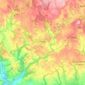
Name: Topografische Karte Priziac, Höhe, Relief.
Durchschnittliche Höhe: 164 m
Minimale Höhe: 57 m
Maximale Höhe: 254 m
Le territoire communal est bordé par deux cours d'eau, au nord-ouest et à l'ouest par la vallée de l'Ellé, au sud par la vallée de l'Aer qui traverse le sud-est de la commune. Ce territoire constitue une sorte de « plateau » dont l'altitude varie de 100 à 230 mètres,altitude maximale de la commune dans le nord de son finage. Cependant, l'altitude minimale de la commune, 56 m, se rencontre quelque part là où l'Ellé quitte le territoire communal, au pied de la Roche-Piriou. Les vallées de l'Ellé et de l'Aer sont par endroits très encaissées, notamment pour cette dernière vallée aux alentours du hameau du Stérou où un pac animalier abritant 150 cervidés, désormais fermé, s'était installé ; le dénivelé y atteint une soixante de mètres entre le plateau et le fond de la vallée.
Andere topografische Karten
Klicken Sie auf eine Karte, um ihre Topografie, ihre Höhe und ihr Relief anzuzeigen.
Saint-Gildas-de-Rhuys
Saint-Gildas-de-Rhuys, Vannes, Morbihan, Bretagne, France métropolitaine, 56730, France
Durchschnittliche Höhe: 12 m
Kernolivès
France > Bretagne > Morbihan > Saint-Gildas-de-Rhuys
Kernolivès, Saint-Gildas-de-Rhuys, Vannes, Morbihan, Bretagne, France métropolitaine, 56730, France
Durchschnittliche Höhe: 18 m
Glénac
France > Bretagne > Morbihan > La Gacilly
Glénac, La Gacilly, Vannes, Morbihan, Bretagne, France métropolitaine, 56200, France
Durchschnittliche Höhe: 31 m
Saint-Tugdual
Saint-Tugdual, Pontivy, Morbihan, Bretagne, France métropolitaine, 56540, France
Durchschnittliche Höhe: 202 m
Larmor-Plage
Larmor-Plage, Lorient, Morbihan, Bretagne, France métropolitaine, 56260, France
Durchschnittliche Höhe: 6 m
Cotillon
France > Bretagne > Morbihan > Inzinzac-Lochrist
Cotillon, Inzinzac-Lochrist, Lorient, Morbihan, Bretagne, France métropolitaine, 56650, France
Durchschnittliche Höhe: 56 m
Korn Er Lann
France > Bretagne > Morbihan > Saint-Aignan
Korn Er Lann, Saint-Aignan, Pontivy, Morbihan, Bretagne, France métropolitaine, 56480, France
Durchschnittliche Höhe: 160 m
Le Val
France > Bretagne > Morbihan > Saint-Martin-sur-Oust
Le Val, Saint-Martin-sur-Oust, Vannes, Morbihan, Bretagne, France métropolitaine, 56200, France
Durchschnittliche Höhe: 44 m
Le Hingleuf
France > Bretagne > Morbihan > Val d'Oust
Le Hingleuf, La Chapelle-Caro, Val d'Oust, Pontivy, Morbihan, Bretagne, France métropolitaine, 56460, France
Durchschnittliche Höhe: 47 m
Le Bout du Pont
France > Bretagne > Morbihan > Val d'Oust
Le Bout du Pont, La Chapelle-Caro, Val d'Oust, Pontivy, Morbihan, Bretagne, France métropolitaine, 56460, France
Durchschnittliche Höhe: 47 m
Brimborion
France > Bretagne > Morbihan > Saint-Guyomard
Brimborion, Saint-Guyomard, Vannes, Morbihan, Bretagne, France métropolitaine, 56460, France
Durchschnittliche Höhe: 67 m
56660
France > Bretagne > Morbihan > Saint-Jean-Brévelay
56660, Saint-Jean-Brévelay, Pontivy, Morbihan, Bretagne, France métropolitaine, France
Durchschnittliche Höhe: 86 m
Lesteno
France > Bretagne > Morbihan > Saint-Nolff
Lesteno, Saint-Nolff, Vannes, Morbihan, Bretagne, France métropolitaine, 56250, France
Durchschnittliche Höhe: 70 m
Le Boizeul
France > Bretagne > Morbihan > Nivillac
Le Boizeul, Nivillac, Vannes, Morbihan, Bretagne, France métropolitaine, 56130, France
Durchschnittliche Höhe: 41 m
Keryarnic
France > Bretagne > Morbihan > Inzinzac-Lochrist
Keryarnic, Inzinzac-Lochrist, Lorient, Morbihan, Bretagne, France métropolitaine, 56650, France
Durchschnittliche Höhe: 63 m